Lengau geodata
Lengau (Upper Austria) is a populated place; located in Austria in Europe/Vienna (GMT+2) time zone. With population of 720 people, there are 1801 cities with bigger population in this country. Compared to other cities in Austria, 66.6% of cities are located further ↓South; 78.8% of cities are located further →East and 58.7% of cities have lower elevation than Lengau. Note1
Administrative division(s):
- Level 1: Upper Austria
- Level 2: Politischer Bezirk Braunau am Inn
- Level 3: Lengau


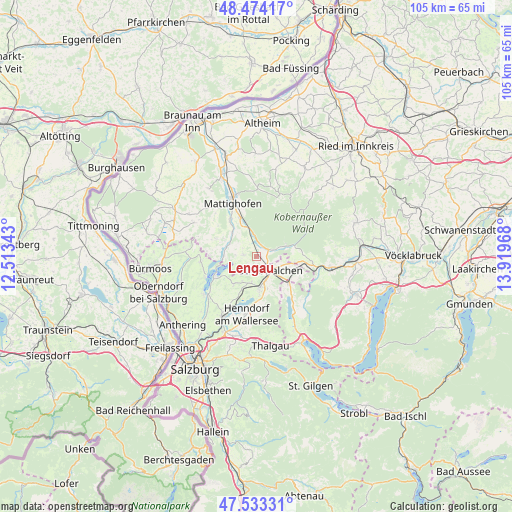
Lengau GPS coordinates[2]
48° 0' 21.204" North, 13° 12' 59.58" East
| Map corner | latitude | longitude |
|---|---|---|
| Upper-left | 48.47417°, | 12.51343° |
| Center: | 48.00589°, | 13.21655° |
| Lower-right: | 47.53331°, | 13.91968° |
| Map W x H: | 104.6×104.6 km | = 65×65mi |
| max Lat: | 48.98333° ⇑33.4% North |
| Lengau: | 48.00589° |
| min Lat: | ⇓66.6% South 46.48841° |
| min Long | Lengau | max Long |
| 9.57802° | 13.21655° | 17.1° |
| W 21.2%⇐ | ⇒78.8% E |
Elevation
Elevation of Lengau is 509 m = 1670 ft, and this is 3.5 m = 11 ft above average elevation for this country.
| Max E: |
2140 m = 7021 ft | 41.3% |
| Lengau | 509 m 1670 ft | |
| Avg. | 505.5 m = 1658 ft | |
Min E: |
118 m = 387 ft | 58.7% |
See also: Austria elevation on elevation.city.
Geographical zone
Lengau is located in North temperate zone (between Tropic of Cancer and the Arctic Circle). Distance of this North polar circle is 2063.4 km =1282.1 mi to North.| Distance of | km | miles | from Lengau |
|---|---|---|---|
| North Pole | 4669.3 | 2901.4 | to North |
| Arctic Circle | 2063.4 | 1282.1 | to North |
| Tropic Cancer | 2731.8 | 1697.5 | to South |
| Equator | 5337.8 | 3316.8 | to South |


Nearby cities:
15 places around Lengau: (largest is in red/bold)
• Friedburg
2.8 km =1.7 mi,  64°
64°
• Irrsdorf
6.6 km =4.1 mi,  131°
131°
• Köstendorf
6.3 km =3.9 mi,  191°
191°
• Lochen
2.7 km =1.7 mi,  274°
274°
• Mattsee
9.7 km =6 mi,  243°
243°
• Munderfing
7.6 km =4.7 mi,  340°
340°
• Neumarkt am Wallersee
6.3 km =3.9 mi,  168°
168°
• Oberhofen am Irrsee
8.8 km =5.5 mi,  135°
135°
• Palting
6.7 km =4.2 mi,  279°
279°
• Pfaffstätt
9.6 km =6 mi,  325°
325°
• Schalkham
8.1 km =5 mi,  179°
179°
• Schleedorf
7.9 km =4.9 mi,  218°
218°
• Schneegattern
6.1 km =3.8 mi,  70°
70°
• Steindorf
5.4 km =3.4 mi,  161°
161°
• Strasswalchen
4.1 km =2.5 mi, 135°
Sources, notices
• [Note1] Compared only with cities in Austria existing in our database
• [Src1] Map data: © OpenStreetMap contributors (CC-BY-SA)
• [Src2] Other city data from geonames.org with taken over terms of usage.
• [Src3] Geographical zone / Annual Mean Temperature by Robert A. Rohde @ Wikipedia
