Lochen geodata
Lochen (Upper Austria) is a populated place; located in Austria in Europe/Vienna (GMT+2) time zone. With population of 785 people, there are 1645 cities with bigger population in this country. Compared to other cities in Austria, 66.8% of cities are located further ↓South; 79.6% of cities are located further →East and 60% of cities have lower elevation than Lochen. Note1
Administrative division(s):
- Level 1: Upper Austria
- Level 2: Politischer Bezirk Braunau am Inn
- Level 3: Lochen


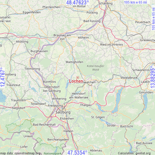
Lochen GPS coordinates[2]
48° 0' 28.656" North, 13° 10' 47.352" East
| Map corner | latitude | longitude |
|---|---|---|
| Upper-left | 48.47623°, | 12.4767° |
| Center: | 48.00796°, | 13.17982° |
| Lower-right: | 47.5354°, | 13.88295° |
| Map W x H: | 104.6×104.6 km | = 65×65mi |
| max Lat: | 48.98333° ⇑33.2% North |
| Lochen: | 48.00796° |
| min Lat: | ⇓66.8% South 46.48841° |
| min Long | Lochen | max Long |
| 9.57802° | 13.17982° | 17.1° |
| W 20.4%⇐ | ⇒79.6% E |
Elevation
Elevation of Lochen is 517 m = 1696 ft, and this is 11.5 m = 38 ft above average elevation for this country.
| Max E: |
2140 m = 7021 ft | 40% |
| Lochen | 517 m 1696 ft | |
| Avg. | 505.5 m = 1658 ft | |
Min E: |
118 m = 387 ft | 60% |
See also: Austria elevation on elevation.city.
Geographical zone
Lochen is located in North temperate zone (between Tropic of Cancer and the Arctic Circle). Distance of this North polar circle is 2063.2 km =1282 mi to North.| Distance of | km | miles | from Lochen |
|---|---|---|---|
| North Pole | 4669.1 | 2901.2 | to North |
| Arctic Circle | 2063.2 | 1282 | to North |
| Tropic Cancer | 2732.1 | 1697.6 | to South |
| Equator | 5338 | 3316.9 | to South |


Nearby cities:
15 places around Lochen: (largest is in red/bold)
• Friedburg
5.3 km =3.3 mi,  79°
79°
• Köstendorf
6.6 km =4.1 mi,  166°
166°
• Lengau
2.7 km =1.7 mi,  94°
94°
• Mattsee
7.5 km =4.7 mi,  232°
232°
• Munderfing
6.9 km =4.3 mi,  1°
1°
• Neumarkt am Wallersee
7.6 km =4.7 mi,  148°
148°
• Palting
4 km =2.5 mi,  281°
281°
• Perwang am Grabensee
7.2 km =4.5 mi,  269°
269°
• Pfaffstätt
8.1 km =5 mi,  340°
340°
• Schalkham
8.7 km =5.4 mi,  161°
161°
• Schleedorf
6.8 km =4.2 mi,  199°
199°
• Schneegattern
8.7 km =5.4 mi, 78°
• Seeham
8.9 km =5.5 mi,  239°
239°
• Steindorf
6.9 km =4.3 mi,  140°
140°
• Strasswalchen
6.5 km =4 mi,  119°
119°
Sources, notices
• [Note1] Compared only with cities in Austria existing in our database
• [Src1] Map data: © OpenStreetMap contributors (CC-BY-SA)
• [Src2] Other city data from geonames.org with taken over terms of usage.
• [Src3] Geographical zone / Annual Mean Temperature by Robert A. Rohde @ Wikipedia
