Leisach geodata
Leisach (Tyrol) is a seat of a third-order administrative division; located in Austria in Europe/Vienna (GMT+2) time zone. With population of 557 people, there are 2289 cities with bigger population in this country. Compared to other cities in Austria, 91.4% of cities are located further ↑North; 85% of cities are located further →East and 81.6% of cities have lower elevation than Leisach. Note1


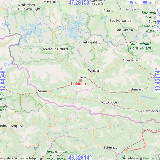
Leisach GPS coordinates[2]
46° 48' 45" North, 12° 44' 54.996" East
| Map corner | latitude | longitude |
|---|---|---|
| Upper-left | 47.29156°, | 12.04549° |
| Center: | 46.8125°, | 12.74861° |
| Lower-right: | 46.32914°, | 13.45174° |
| Map W x H: | 107×107 km | = 66.5×66.5mi |
| max Lat: | 48.98333° ⇑91.4% North |
| Leisach: | 46.8125° |
| min Lat: | ⇓8.6% South 46.48841° |
| min Long | Leisach | max Long |
| 9.57802° | 12.74861° | 17.1° |
| W 15%⇐ | ⇒85% E |
Elevation
Elevation of Leisach is 745 m = 2444 ft, and this is 239.5 m = 786 ft above average elevation for this country.
| Max E: |
2140 m = 7021 ft | 18.4% |
| Leisach | 745 m 2444 ft | |
| Avg. | 505.5 m = 1658 ft | |
Min E: |
118 m = 387 ft | 81.6% |
See also: Austria elevation on elevation.city.
Geographical zone
Leisach is located in North temperate zone (between Tropic of Cancer and the Arctic Circle). Distance of this North polar circle is 2196.1 km =1364.6 mi to North.| Distance of | km | miles | from Leisach |
|---|---|---|---|
| North Pole | 4802 | 2983.8 | to North |
| Arctic Circle | 2196.1 | 1364.6 | to North |
| Tropic Cancer | 2599.1 | 1615 | to South |
| Equator | 5205.1 | 3234.3 | to South |


Nearby cities:
15 places around Leisach: (largest is in red/bold)
• Ainet
7.5 km =4.7 mi,  323°
323°
• Amlach
1.2 km =0.7 mi,  69°
69°
• Assling
8.8 km =5.5 mi,  250°
250°
• Debant
5.7 km =3.5 mi, 65°
• Dölsach
7.6 km =4.7 mi,  76°
76°
• Lavant
7 km =4.3 mi,  102°
102°
• Lienz
2.4 km =1.5 mi,  40°
40°
• Nikolsdorf
12.9 km =8 mi, 103°
• Nußdorf
4.5 km =2.8 mi,  59°
59°
• Oberlienz
4.1 km =2.5 mi,  341°
341°
• Schlaiten
10.3 km =6.4 mi, 316°
• Thurn
4.5 km =2.8 mi,  19°
19°
• Tristach
3.2 km =2 mi, 82°
• Untertilliach
13.3 km =8.3 mi,  204°
204°
• Winklern
11.8 km =7.3 mi,  54°
54°
Sources, notices
• [Note1] Compared only with cities in Austria existing in our database
• [Src1] Map data: © OpenStreetMap contributors (CC-BY-SA)
• [Src2] Other city data from geonames.org with taken over terms of usage.
• [Src3] Geographical zone / Annual Mean Temperature by Robert A. Rohde @ Wikipedia
