Dölsach geodata
Dölsach (Tyrol) is a seat of a third-order administrative division; located in Austria in Europe/Vienna (GMT+2) time zone. With population of 1,090 people, there are 1174 cities with bigger population in this country. Compared to other cities in Austria, 90.7% of cities are located further ↑North; 84.2% of cities are located further →East and 87.5% of cities have lower elevation than Dölsach. Note1


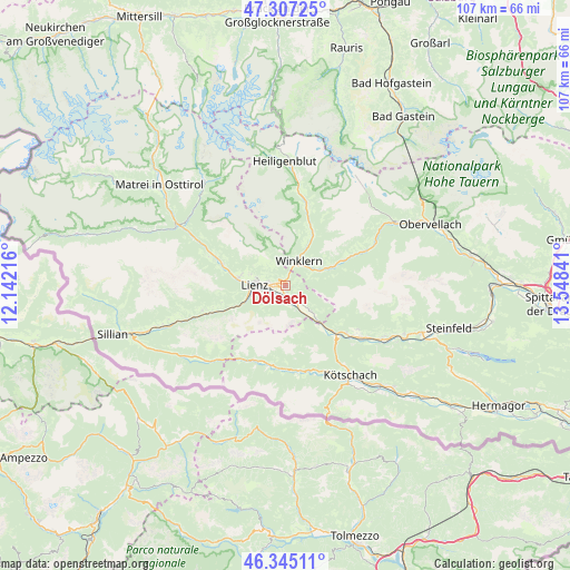
Dölsach GPS coordinates[2]
46° 49' 41.988" North, 12° 50' 43.008" East
| Map corner | latitude | longitude |
|---|---|---|
| Upper-left | 47.30725°, | 12.14216° |
| Center: | 46.82833°, | 12.84528° |
| Lower-right: | 46.34511°, | 13.54841° |
| Map W x H: | 107×107 km | = 66.5×66.5mi |
| max Lat: | 48.98333° ⇑90.7% North |
| Dölsach: | 46.82833° |
| min Lat: | ⇓9.3% South 46.48841° |
| min Long | Dölsach | max Long |
| 9.57802° | 12.84528° | 17.1° |
| W 15.8%⇐ | ⇒84.2% E |
Elevation
Elevation of Dölsach is 836 m = 2743 ft, and this is 330.5 m = 1084 ft above average elevation for this country.
| Max E: |
2140 m = 7021 ft | 12.5% |
| Dölsach | 836 m 2743 ft | |
| Avg. | 505.5 m = 1658 ft | |
Min E: |
118 m = 387 ft | 87.5% |
See also: Austria elevation on elevation.city.
Geographical zone
Dölsach is located in North temperate zone (between Tropic of Cancer and the Arctic Circle). Distance of this North polar circle is 2194.4 km =1363.5 mi to North.| Distance of | km | miles | from Dölsach |
|---|---|---|---|
| North Pole | 4800.2 | 2982.7 | to North |
| Arctic Circle | 2194.4 | 1363.5 | to North |
| Tropic Cancer | 2600.9 | 1616.1 | to South |
| Equator | 5206.8 | 3235.4 | to South |


Nearby cities:
15 places around Dölsach: (largest is in red/bold)
• Ainet
12.6 km =7.8 mi,  289°
289°
• Amlach
6.4 km =4 mi,  257°
257°
• Debant
2.2 km =1.4 mi,  284°
284°
• Lavant
3.3 km =2.1 mi,  189°
189°
• Leisach
7.6 km =4.7 mi, 256°
• Lienz
5.8 km =3.6 mi,  270°
270°
• Mörtschach
12 km =7.5 mi,  27°
27°
• Nikolsdorf
7 km =4.3 mi,  132°
132°
• Nußdorf
3.5 km =2.2 mi, 279°
• Oberdrauburg
13.4 km =8.3 mi, 134°
• Oberlienz
8.9 km =5.5 mi, 283°
• Rangersdorf
8.7 km =5.4 mi,  65°
65°
• Thurn
6.3 km =3.9 mi, 292°
• Tristach
4.4 km =2.7 mi,  252°
252°
• Winklern
5.5 km =3.4 mi,  23°
23°
Sources, notices
• [Note1] Compared only with cities in Austria existing in our database
• [Src1] Map data: © OpenStreetMap contributors (CC-BY-SA)
• [Src2] Other city data from geonames.org with taken over terms of usage.
• [Src3] Geographical zone / Annual Mean Temperature by Robert A. Rohde @ Wikipedia
