Hofkirchen geodata
Hofkirchen (Styria) is a populated place; located in Austria in Europe/Vienna (GMT+2) time zone. With population of 669 people, there are 1936 cities with bigger population in this country. Compared to other cities in Austria, 69.5% of cities are located further ↑North; 77.1% of cities are located further ←West and 64.9% of cities have higher elevation than Hofkirchen. Note1
Administrative division(s):
- Level 1: Styria
- Level 2: Politischer Bezirk Hartberg-Fürstenfeld
- Level 3: Kaindorf


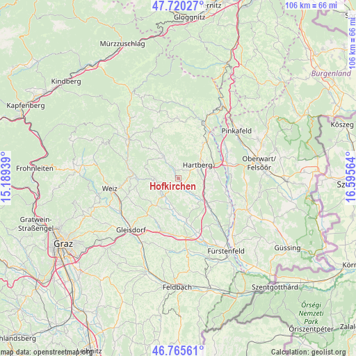
Hofkirchen GPS coordinates[2]
47° 14' 42.324" North, 15° 53' 33.036" East
| Map corner | latitude | longitude |
|---|---|---|
| Upper-left | 47.72027°, | 15.18939° |
| Center: | 47.24509°, | 15.89251° |
| Lower-right: | 46.76561°, | 16.59564° |
| Map W x H: | 106.1×106.1 km | = 65.9×65.9mi |
| max Lat: | 48.98333° ⇑69.5% North |
| Hofkirchen: | 47.24509° |
| min Lat: | ⇓30.5% South 46.48841° |
| min Long | Hofkirchen | max Long |
| 9.57802° | 15.89251° | 17.1° |
| W 77.1%⇐ | ⇒22.9% E |
Elevation
Elevation of Hofkirchen is 354 m = 1161 ft, and this is 151.5 m = 497 ft below average elevation for this country.
| Max E: |
2140 m = 7021 ft | 64.9% |
| Avg. | 505.5 m = 1658 ft | |
| Hofkirchen | 354 m = 1161 ft | |
Min E: |
118 m = 387 ft | 35.1% |
See also: Austria elevation on elevation.city.
Geographical zone
Hofkirchen is located in North temperate zone (between Tropic of Cancer and the Arctic Circle). Distance of this North polar circle is 2148 km =1334.7 mi to North.| Distance of | km | miles | from Hofkirchen |
|---|---|---|---|
| North Pole | 4753.9 | 2953.9 | to North |
| Arctic Circle | 2148 | 1334.7 | to North |
| Tropic Cancer | 2647.2 | 1644.9 | to South |
| Equator | 5253.2 | 3264.2 | to South |


Nearby cities:
15 places around Hofkirchen: (largest is in red/bold)
• Blaindorf
8 km =5 mi,  193°
193°
• Dienersdorf
0.9 km =0.6 mi,  131°
131°
• Ebersdorf
7.4 km =4.6 mi, 134°
• Flattendorf
3 km =1.9 mi,  37°
37°
• Hartberg
7 km =4.3 mi,  52°
52°
• Hartl
7.1 km =4.4 mi,  165°
165°
• Hirnsdorf
7.6 km =4.7 mi,  219°
219°
• Kaibing
6.7 km =4.2 mi, 221°
• Kaindorf
2.6 km =1.6 mi,  147°
147°
• Löffelbach
5.3 km =3.3 mi, 35°
• Pöllau
7.6 km =4.7 mi,  323°
323°
• Ring
7.1 km =4.4 mi, 49°
• Safenau
7.3 km =4.5 mi,  70°
70°
• Stubenberg
7 km =4.3 mi,  269°
269°
• Unterbuch
7.6 km =4.7 mi,  105°
105°
Sources, notices
• [Note1] Compared only with cities in Austria existing in our database
• [Src1] Map data: © OpenStreetMap contributors (CC-BY-SA)
• [Src2] Other city data from geonames.org with taken over terms of usage.
• [Src3] Geographical zone / Annual Mean Temperature by Robert A. Rohde @ Wikipedia
