Jungholz geodata
Jungholz (Tyrol) is a seat of a third-order administrative division; located in Austria in Europe/Vienna (GMT+2) time zone. With population of 301 people, there are 2739 cities with bigger population in this country. Compared to other cities in Austria, 50.7% of cities are located further ↑North; 96.2% of cities are located further →East and 95.7% of cities have lower elevation than Jungholz. Note1


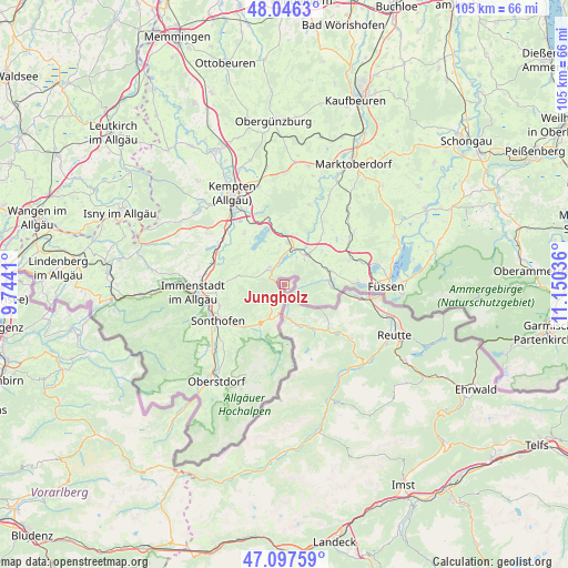
Jungholz GPS coordinates[2]
47° 34' 26.724" North, 10° 26' 50.028" East
| Map corner | latitude | longitude |
|---|---|---|
| Upper-left | 48.0463°, | 9.7441° |
| Center: | 47.57409°, | 10.44723° |
| Lower-right: | 47.09759°, | 11.15036° |
| Map W x H: | 105.5×105.5 km | = 65.6×65.6mi |
| max Lat: | 48.98333° ⇑50.7% North |
| Jungholz: | 47.57409° |
| min Lat: | ⇓49.3% South 46.48841° |
| min Long | Jungholz | max Long |
| 9.57802° | 10.44723° | 17.1° |
| W 3.8%⇐ | ⇒96.2% E |
Elevation
Elevation of Jungholz is 1057 m = 3468 ft, and this is 551.5 m = 1809 ft above average elevation for this country.
| Max E: |
2140 m = 7021 ft | 4.3% |
| Jungholz | 1057 m 3468 ft | |
| Avg. | 505.5 m = 1658 ft | |
Min E: |
118 m = 387 ft | 95.7% |
See also: Austria elevation on elevation.city.
Geographical zone
Jungholz is located in North temperate zone (between Tropic of Cancer and the Arctic Circle). Distance of this North polar circle is 2111.4 km =1312 mi to North.| Distance of | km | miles | from Jungholz |
|---|---|---|---|
| North Pole | 4717.3 | 2931.2 | to North |
| Arctic Circle | 2111.4 | 1312 | to North |
| Tropic Cancer | 2683.8 | 1667.6 | to South |
| Equator | 5289.7 | 3286.9 | to South |


Nearby cities:
15 places around Jungholz: (largest is in red/bold)
• Ehenbichl
22.4 km =13.9 mi,  122°
122°
• Forchach
20.3 km =12.6 mi,  149°
149°
• Grän
11.3 km =7 mi,  136°
136°
• Höfen
21.4 km =13.3 mi, 123°
• Lechaschau
21.7 km =13.5 mi, 116°
• Musau
17.6 km =10.9 mi,  105°
105°
• Nesselwängle
16.2 km =10.1 mi,  128°
128°
• Pflach
21.2 km =13.2 mi, 107°
• Reutte
22.6 km =14 mi, 116°
• Schattwald
6.7 km =4.2 mi,  170°
170°
• Tannheim
9.8 km =6.1 mi, 148°
• Vils
14.2 km =8.8 mi,  100°
100°
• Weissenbach am Lech
20.7 km =12.9 mi, 135°
• Wängle
20.7 km =12.9 mi, 118°
• Zöblen
7.8 km =4.8 mi,  161°
161°
Sources, notices
• [Note1] Compared only with cities in Austria existing in our database
• [Src1] Map data: © OpenStreetMap contributors (CC-BY-SA)
• [Src2] Other city data from geonames.org with taken over terms of usage.
• [Src3] Geographical zone / Annual Mean Temperature by Robert A. Rohde @ Wikipedia
