Tannheim geodata
Tannheim (Tyrol) is a seat of a third-order administrative division; located in Austria in Europe/Vienna (GMT+2) time zone. With population of 1,067 people, there are 1198 cities with bigger population in this country. Compared to other cities in Austria, 53.9% of cities are located further ↑North; 95.9% of cities are located further →East and 96.5% of cities have lower elevation than Tannheim. Note1


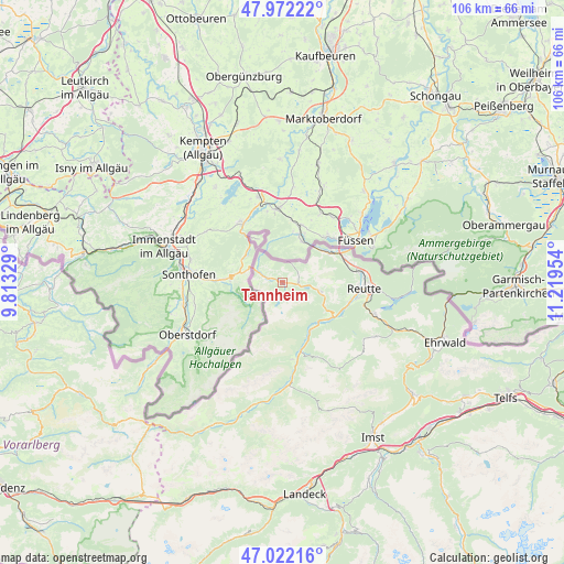
Tannheim GPS coordinates[2]
47° 29' 57.624" North, 10° 30' 59.076" East
| Map corner | latitude | longitude |
|---|---|---|
| Upper-left | 47.97222°, | 9.81329° |
| Center: | 47.49934°, | 10.51641° |
| Lower-right: | 47.02216°, | 11.21954° |
| Map W x H: | 105.6×105.6 km | = 65.6×65.6mi |
| max Lat: | 48.98333° ⇑53.9% North |
| Tannheim: | 47.49934° |
| min Lat: | ⇓46.1% South 46.48841° |
| min Long | Tannheim | max Long |
| 9.57802° | 10.51641° | 17.1° |
| W 4.1%⇐ | ⇒95.9% E |
Elevation
Elevation of Tannheim is 1099 m = 3606 ft, and this is 593.5 m = 1947 ft above average elevation for this country.
| Max E: |
2140 m = 7021 ft | 3.5% |
| Tannheim | 1099 m 3606 ft | |
| Avg. | 505.5 m = 1658 ft | |
Min E: |
118 m = 387 ft | 96.5% |
See also: Austria elevation on elevation.city.
Geographical zone
Tannheim is located in North temperate zone (between Tropic of Cancer and the Arctic Circle). Distance of this North polar circle is 2119.7 km =1317.1 mi to North.| Distance of | km | miles | from Tannheim |
|---|---|---|---|
| North Pole | 4725.6 | 2936.4 | to North |
| Arctic Circle | 2119.7 | 1317.1 | to North |
| Tropic Cancer | 2675.5 | 1662.5 | to South |
| Equator | 5281.4 | 3281.7 | to South |


Nearby cities:
15 places around Tannheim: (largest is in red/bold)
• Ehenbichl
14.3 km =8.9 mi,  104°
104°
• Forchach
10.5 km =6.5 mi,  151°
151°
• Grän
2.5 km =1.6 mi,  88°
88°
• Höfen
13.1 km =8.1 mi,  106°
106°
• Jungholz
9.8 km =6.1 mi,  328°
328°
• Lechaschau
14.3 km =8.9 mi, 95°
• Musau
12.3 km =7.6 mi,  72°
72°
• Nesselwängle
7.7 km =4.8 mi, 103°
• Schattwald
4.5 km =2.8 mi,  291°
291°
• Stanzach
13.4 km =8.3 mi,  163°
163°
• Vils
10.4 km =6.5 mi,  57°
57°
• Vorderhornbach
14.5 km =9 mi,  173°
173°
• Weissenbach am Lech
11.3 km =7 mi,  124°
124°
• Wängle
13.1 km =8.1 mi, 96°
• Zöblen
2.9 km =1.8 mi, 288°
Sources, notices
• [Note1] Compared only with cities in Austria existing in our database
• [Src1] Map data: © OpenStreetMap contributors (CC-BY-SA)
• [Src2] Other city data from geonames.org with taken over terms of usage.
• [Src3] Geographical zone / Annual Mean Temperature by Robert A. Rohde @ Wikipedia
