Zöblen geodata
Zöblen (Tyrol) is a seat of a third-order administrative division; located in Austria in Europe/Vienna (GMT+2) time zone. With population of 231 people, there are 2828 cities with bigger population in this country. Compared to other cities in Austria, 53.4% of cities are located further ↑North; 96.1% of cities are located further →East and 96.3% of cities have lower elevation than Zöblen. Note1


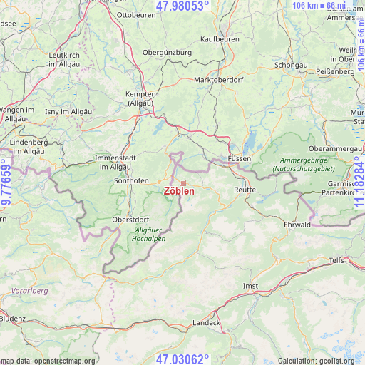
Zöblen GPS coordinates[2]
47° 30' 27.792" North, 10° 28' 46.956" East
| Map corner | latitude | longitude |
|---|---|---|
| Upper-left | 47.98053°, | 9.77659° |
| Center: | 47.50772°, | 10.47971° |
| Lower-right: | 47.03062°, | 11.18284° |
| Map W x H: | 105.6×105.6 km | = 65.6×65.6mi |
| max Lat: | 48.98333° ⇑53.4% North |
| Zöblen: | 47.50772° |
| min Lat: | ⇓46.6% South 46.48841° |
| min Long | Zöblen | max Long |
| 9.57802° | 10.47971° | 17.1° |
| W 3.9%⇐ | ⇒96.1% E |
Elevation
Elevation of Zöblen is 1089 m = 3573 ft, and this is 583.5 m = 1914 ft above average elevation for this country.
| Max E: |
2140 m = 7021 ft | 3.7% |
| Zöblen | 1089 m 3573 ft | |
| Avg. | 505.5 m = 1658 ft | |
Min E: |
118 m = 387 ft | 96.3% |
See also: Austria elevation on elevation.city.
Geographical zone
Zöblen is located in North temperate zone (between Tropic of Cancer and the Arctic Circle). Distance of this North polar circle is 2118.8 km =1316.6 mi to North.| Distance of | km | miles | from Zöblen |
|---|---|---|---|
| North Pole | 4724.7 | 2935.8 | to North |
| Arctic Circle | 2118.8 | 1316.6 | to North |
| Tropic Cancer | 2676.4 | 1663 | to South |
| Equator | 5282.4 | 3282.3 | to South |


Nearby cities:
15 places around Zöblen: (largest is in red/bold)
• Ehenbichl
17.2 km =10.7 mi,  105°
105°
• Forchach
12.8 km =8 mi,  142°
142°
• Grän
5.3 km =3.3 mi,  99°
99°
• Höfen
16 km =9.9 mi, 106°
• Jungholz
7.8 km =4.8 mi,  341°
341°
• Lechaschau
17.2 km =10.7 mi, 97°
• Musau
14.8 km =9.2 mi,  79°
79°
• Nesselwängle
10.6 km =6.6 mi, 104°
• Schattwald
1.6 km =1 mi,  297°
297°
• Stanzach
15.3 km =9.5 mi,  154°
154°
• Tannheim
2.9 km =1.8 mi, 108°
• Vils
12.5 km =7.8 mi,  67°
67°
• Vorderhornbach
15.9 km =9.9 mi,  163°
163°
• Weissenbach am Lech
14.2 km =8.8 mi,  121°
121°
• Wängle
16 km =9.9 mi, 98°
Sources, notices
• [Note1] Compared only with cities in Austria existing in our database
• [Src1] Map data: © OpenStreetMap contributors (CC-BY-SA)
• [Src2] Other city data from geonames.org with taken over terms of usage.
• [Src3] Geographical zone / Annual Mean Temperature by Robert A. Rohde @ Wikipedia
