Innermanzing geodata
Innermanzing (Lower Austria) is a populated place; located in Austria in Europe/Vienna (GMT+2) time zone. With population of 739 people, there are 1748 cities with bigger population in this country. Compared to other cities in Austria, 74.7% of cities are located further ↓South; 77.8% of cities are located further ←West and 76.6% of cities have higher elevation than Innermanzing. Note1
Administrative division(s):
- Level 1: Lower Austria
- Level 2: Politischer Bezirk Sankt Pölten
- Level 3: Neustift-Innermanzing


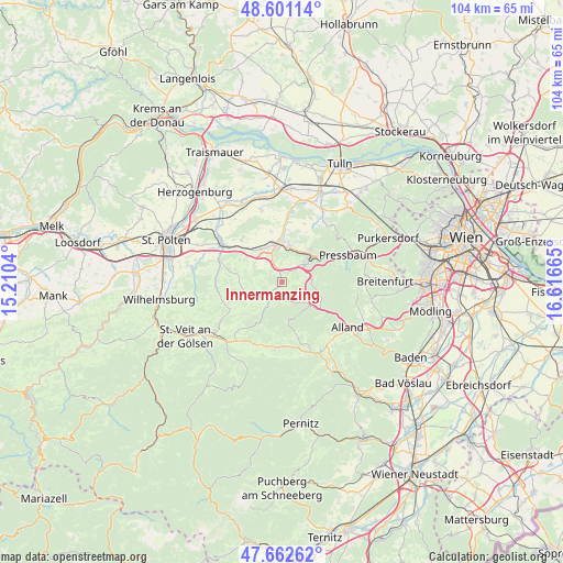
Innermanzing GPS coordinates[2]
48° 8' 2.472" North, 15° 54' 48.672" East
| Map corner | latitude | longitude |
|---|---|---|
| Upper-left | 48.60114°, | 15.2104° |
| Center: | 48.13402°, | 15.91352° |
| Lower-right: | 47.66262°, | 16.61665° |
| Map W x H: | 104.4×104.4 km | = 64.9×64.9mi |
| max Lat: | 48.98333° ⇑25.3% North |
| Innermanzing: | 48.13402° |
| min Lat: | ⇓74.7% South 46.48841° |
| min Long | Innermanzing | max Long |
| 9.57802° | 15.91352° | 17.1° |
| W 77.8%⇐ | ⇒22.2% E |
Elevation
Elevation of Innermanzing is 293 m = 961 ft, and this is 212.5 m = 697 ft below average elevation for this country.
| Max E: |
2140 m = 7021 ft | 76.6% |
| Avg. | 505.5 m = 1658 ft | |
| Innermanzing | 293 m = 961 ft | |
Min E: |
118 m = 387 ft | 23.4% |
See also: Austria elevation on elevation.city.
Geographical zone
Innermanzing is located in North temperate zone (between Tropic of Cancer and the Arctic Circle). Distance of this North polar circle is 2049.2 km =1273.3 mi to North.| Distance of | km | miles | from Innermanzing |
|---|---|---|---|
| North Pole | 4655.1 | 2892.5 | to North |
| Arctic Circle | 2049.2 | 1273.3 | to North |
| Tropic Cancer | 2746.1 | 1706.3 | to South |
| Equator | 5352 | 3325.6 | to South |


Nearby cities:
15 places around Innermanzing: (largest is in red/bold)
• Altlengbach
2.4 km =1.5 mi,  23°
23°
• Au am Anzbach
7.5 km =4.7 mi,  4°
4°
• Ebersberg
7.2 km =4.5 mi,  346°
346°
• Eichgraben
6.7 km =4.2 mi,  51°
51°
• Haag
6.3 km =3.9 mi, 351°
• Hinterleiten
5.2 km =3.2 mi, 48°
• Hutten
7.3 km =4.5 mi, 47°
• Kirchstetten
9 km =5.6 mi,  307°
307°
• Klausen-Leopoldsdorf
9.2 km =5.7 mi,  123°
123°
• Maria-Anzbach
6.4 km =4 mi,  12°
12°
• Neulengbach
7.1 km =4.4 mi, 353°
• Ollersbach
7.8 km =4.8 mi,  318°
318°
• Ottenheim
6.5 km =4 mi, 45°
• Stein
7.9 km =4.9 mi,  39°
39°
• Stössing
7.5 km =4.7 mi,  260°
260°
Sources, notices
• [Note1] Compared only with cities in Austria existing in our database
• [Src1] Map data: © OpenStreetMap contributors (CC-BY-SA)
• [Src2] Other city data from geonames.org with taken over terms of usage.
• [Src3] Geographical zone / Annual Mean Temperature by Robert A. Rohde @ Wikipedia
