Klausen-Leopoldsdorf geodata
Klausen-Leopoldsdorf (Lower Austria) is a seat of a third-order administrative division; located in Austria in Europe/Vienna (GMT+2) time zone. With population of 1,681 people, there are 745 cities with bigger population in this country. Compared to other cities in Austria, 72% of cities are located further ↓South; 80.9% of cities are located further ←West and 61.5% of cities have higher elevation than Klausen-Leopoldsdorf. Note1
Administrative division(s):
- Level 1: Lower Austria
- Level 2: Politischer Bezirk Baden
- Level 3: Klausen-Leopoldsdorf


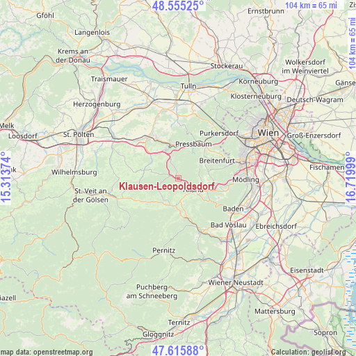
Klausen-Leopoldsdorf GPS coordinates[2]
48° 5' 15.756" North, 16° 1' 0.696" East
| Map corner | latitude | longitude |
|---|---|---|
| Upper-left | 48.55525°, | 15.31374° |
| Center: | 48.08771°, | 16.01686° |
| Lower-right: | 47.61588°, | 16.71999° |
| Map W x H: | 104.4×104.4 km | = 64.9×64.9mi |
| max Lat: | 48.98333° ⇑28% North |
| Klausen-Leopoldsdorf: | 48.08771° |
| min Lat: | ⇓72% South 46.48841° |
| min Long | Klausen-Leopold | max Long |
| 9.57802° | 16.01686° | 17.1° |
| W 80.9%⇐ | ⇒19.1% E |
Elevation
Elevation of Klausen-Leopoldsdorf is 373 m = 1224 ft, and this is 132.5 m = 435 ft below average elevation for this country.
| Max E: |
2140 m = 7021 ft | 61.5% |
| Avg. | 505.5 m = 1658 ft | |
| Klausen-Leopoldsdorf | 373 m = 1224 ft | |
Min E: |
118 m = 387 ft | 38.5% |
See also: Austria elevation on elevation.city.
Geographical zone
Klausen-Leopoldsdorf is located in North temperate zone (between Tropic of Cancer and the Arctic Circle). Distance of this North polar circle is 2054.3 km =1276.5 mi to North.| Distance of | km | miles | from Klausen-Leopoldsdorf |
|---|---|---|---|
| North Pole | 4660.2 | 2895.7 | to North |
| Arctic Circle | 2054.3 | 1276.5 | to North |
| Tropic Cancer | 2740.9 | 1703.1 | to South |
| Equator | 5346.9 | 3322.4 | to South |


Nearby cities:
15 places around Klausen-Leopoldsdorf: (largest is in red/bold)
• Alland
5.7 km =3.5 mi,  125°
125°
• Altenmarkt an der Triesting
8.2 km =5.1 mi,  190°
190°
• Altlengbach
10 km =6.2 mi,  317°
317°
• Eichgraben
9.7 km =6 mi,  345°
345°
• Grub
7.1 km =4.4 mi,  97°
97°
• Heiligenkreuz
8.8 km =5.5 mi,  113°
113°
• Hinterleiten
9.4 km =5.8 mi,  336°
336°
• Hutten
10.4 km =6.5 mi, 347°
• Innermanzing
9.2 km =5.7 mi,  303°
303°
• Neuhaus
10.5 km =6.5 mi,  168°
168°
• Ottenheim
10.2 km =6.3 mi, 342°
• Pfalzau
8.8 km =5.5 mi,  22°
22°
• Rekawinkel
10.2 km =6.3 mi,  3°
3°
• Sulz im Wienerwald
9.1 km =5.7 mi,  81°
81°
• Thenneberg
8.7 km =5.4 mi,  205°
205°
In other languages:
- In German: Klausenleopoldsdorf
- In Russian: Клаузен-Леопольдсдорф
- In Chinese: 克劳森-莱奥波尔德斯多夫
Sources, notices
• [Note1] Compared only with cities in Austria existing in our database
• [Src1] Map data: © OpenStreetMap contributors (CC-BY-SA)
• [Src2] Other city data from geonames.org with taken over terms of usage.
• [Src3] Geographical zone / Annual Mean Temperature by Robert A. Rohde @ Wikipedia
