Hutten geodata
Hutten (Lower Austria) is a populated place; located in Austria in Europe/Vienna (GMT+2) time zone. With population of 1,428 people, there are 881 cities with bigger population in this country. Compared to other cities in Austria, 77.6% of cities are located further ↓South; 79.9% of cities are located further ←West and 79.2% of cities have higher elevation than Hutten. Note1
Administrative division(s):
- Level 1: Lower Austria
- Level 2: Politischer Bezirk Sankt Pölten
- Level 3: Eichgraben


Hutten GPS coordinates[2]
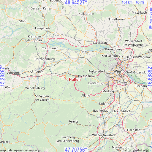
48° 10' 42.816" North, 15° 59' 8.844" East
| Map corner | latitude | longitude |
|---|---|---|
| Upper-left | 48.64527°, | 15.28267° |
| Center: | 48.17856°, | 15.98579° |
| Lower-right: | 47.70756°, | 16.68892° |
| Map W x H: | 104.3×104.3 km | = 64.8×64.8mi |
| max Lat: | 48.98333° ⇑22.4% North |
| Hutten: | 48.17856° |
| min Lat: | ⇓77.6% South 46.48841° |
| min Long | Hutten | max Long |
| 9.57802° | 15.98579° | 17.1° |
| W 79.9%⇐ | ⇒20.1% E |
Elevation
Elevation of Hutten is 278 m = 912 ft, and this is 227.5 m = 746 ft below average elevation for this country.
| Max E: |
2140 m = 7021 ft | 79.2% |
| Avg. | 505.5 m = 1658 ft | |
| Hutten | 278 m = 912 ft | |
Min E: |
118 m = 387 ft | 20.8% |
See also: Austria elevation on elevation.city.
Geographical zone
Hutten is located in North temperate zone (between Tropic of Cancer and the Arctic Circle). Distance of this North polar circle is 2044.2 km =1270.2 mi to North.| Distance of | km | miles | from Hutten |
|---|---|---|---|
| North Pole | 4650.1 | 2889.4 | to North |
| Arctic Circle | 2044.2 | 1270.2 | to North |
| Tropic Cancer | 2751 | 1709.4 | to South |
| Equator | 5357 | 3328.7 | to South |


Nearby cities:
15 places around Hutten: (largest is in red/bold)
• Altlengbach
5.2 km =3.2 mi,  237°
237°
• Au am Anzbach
5.4 km =3.4 mi,  297°
297°
• Ebersberg
7.3 km =4.5 mi,  286°
286°
• Eichgraben
0.7 km =0.4 mi,  190°
190°
• Haag
6.4 km =4 mi,  281°
281°
• Hinterleiten
2.1 km =1.3 mi,  223°
223°
• Innermanzing
7.3 km =4.5 mi,  227°
227°
• Maria-Anzbach
4.2 km =2.6 mi, 287°
• Neulengbach
6.5 km =4 mi, 288°
• Ottenheim
0.8 km =0.5 mi,  245°
245°
• Pfalzau
6 km =3.7 mi,  109°
109°
• Pressbaum
7.3 km =4.5 mi,  85°
85°
• Rekawinkel
2.9 km =1.8 mi, 88°
• Stein
1.3 km =0.8 mi,  342°
342°
• Tullnerbach-Lawies
7.9 km =4.9 mi,  81°
81°
Sources, notices
• [Note1] Compared only with cities in Austria existing in our database
• [Src1] Map data: © OpenStreetMap contributors (CC-BY-SA)
• [Src2] Other city data from geonames.org with taken over terms of usage.
• [Src3] Geographical zone / Annual Mean Temperature by Robert A. Rohde @ Wikipedia
