Hinterleiten geodata
Hinterleiten (Lower Austria) is a populated place; located in Austria in Europe/Vienna (GMT+2) time zone. With population of 1,323 people, there are 954 cities with bigger population in this country. Compared to other cities in Austria, 76.7% of cities are located further ↓South; 79.3% of cities are located further ←West and 62.5% of cities have higher elevation than Hinterleiten. Note1
Administrative division(s):
- Level 1: Lower Austria
- Level 2: Politischer Bezirk Sankt Pölten
- Level 3: Eichgraben


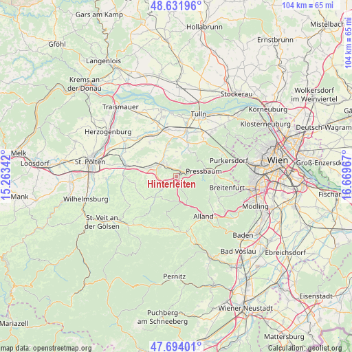
Hinterleiten GPS coordinates[2]
48° 9' 54.468" North, 15° 57' 59.544" East
| Map corner | latitude | longitude |
|---|---|---|
| Upper-left | 48.63196°, | 15.26342° |
| Center: | 48.16513°, | 15.96654° |
| Lower-right: | 47.69401°, | 16.66967° |
| Map W x H: | 104.3×104.3 km | = 64.8×64.8mi |
| max Lat: | 48.98333° ⇑23.3% North |
| Hinterleiten: | 48.16513° |
| min Lat: | ⇓76.7% South 46.48841° |
| min Long | Hinterleiten | max Long |
| 9.57802° | 15.96654° | 17.1° |
| W 79.3%⇐ | ⇒20.7% E |
Elevation
Elevation of Hinterleiten is 368 m = 1207 ft, and this is 137.5 m = 451 ft below average elevation for this country.
| Max E: |
2140 m = 7021 ft | 62.5% |
| Avg. | 505.5 m = 1658 ft | |
| Hinterleiten | 368 m = 1207 ft | |
Min E: |
118 m = 387 ft | 37.5% |
See also: Austria elevation on elevation.city.
Geographical zone
Hinterleiten is located in North temperate zone (between Tropic of Cancer and the Arctic Circle). Distance of this North polar circle is 2045.7 km =1271.1 mi to North.| Distance of | km | miles | from Hinterleiten |
|---|---|---|---|
| North Pole | 4651.6 | 2890.4 | to North |
| Arctic Circle | 2045.7 | 1271.1 | to North |
| Tropic Cancer | 2749.5 | 1708.5 | to South |
| Equator | 5355.5 | 3327.8 | to South |


Nearby cities:
15 places around Hinterleiten: (largest is in red/bold)
• Altlengbach
3.3 km =2.1 mi,  246°
246°
• Au am Anzbach
5.2 km =3.2 mi,  320°
320°
• Ebersberg
6.6 km =4.1 mi,  302°
302°
• Eichgraben
1.5 km =0.9 mi,  59°
59°
• Haag
5.6 km =3.5 mi, 300°
• Hutten
2.1 km =1.3 mi,  43°
43°
• Innermanzing
5.2 km =3.2 mi,  228°
228°
• Klausen-Leopoldsdorf
9.4 km =5.8 mi,  156°
156°
• Maria-Anzbach
3.8 km =2.4 mi, 316°
• Neulengbach
6 km =3.7 mi,  306°
306°
• Ottenheim
1.4 km =0.9 mi,  31°
31°
• Pfalzau
7.2 km =4.5 mi,  94°
94°
• Pressbaum
8.9 km =5.5 mi,  76°
76°
• Rekawinkel
4.6 km =2.9 mi,  69°
69°
• Stein
2.9 km =1.8 mi,  21°
21°
Sources, notices
• [Note1] Compared only with cities in Austria existing in our database
• [Src1] Map data: © OpenStreetMap contributors (CC-BY-SA)
• [Src2] Other city data from geonames.org with taken over terms of usage.
• [Src3] Geographical zone / Annual Mean Temperature by Robert A. Rohde @ Wikipedia
