Haag geodata
Haag (Lower Austria) is a populated place; located in Austria in Europe/Vienna (GMT+2) time zone. With population of 1,005 people, there are 1285 cities with bigger population in this country. Compared to other cities in Austria, 78.7% of cities are located further ↓South; 77.4% of cities are located further ←West and 85.4% of cities have higher elevation than Haag. Note1
Administrative division(s):
- Level 1: Lower Austria
- Level 2: Politischer Bezirk Sankt Pölten
- Level 3: Neulengbach


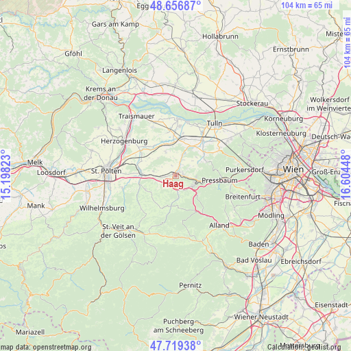
Haag GPS coordinates[2]
48° 11' 24.972" North, 15° 54' 4.86" East
| Map corner | latitude | longitude |
|---|---|---|
| Upper-left | 48.65687°, | 15.19823° |
| Center: | 48.19027°, | 15.90135° |
| Lower-right: | 47.71938°, | 16.60448° |
| Map W x H: | 104.2×104.2 km | = 64.7×64.7mi |
| max Lat: | 48.98333° ⇑21.3% North |
| Haag: | 48.19027° |
| min Lat: | ⇓78.7% South 46.48841° |
| min Long | Haag | max Long |
| 9.57802° | 15.90135° | 17.1° |
| W 77.4%⇐ | ⇒22.6% E |
Elevation
Elevation of Haag is 245 m = 804 ft, and this is 260.5 m = 855 ft below average elevation for this country.
| Max E: |
2140 m = 7021 ft | 85.4% |
| Avg. | 505.5 m = 1658 ft | |
| Haag | 245 m = 804 ft | |
Min E: |
118 m = 387 ft | 14.6% |
See also: Austria elevation on elevation.city.
Geographical zone
Haag is located in North temperate zone (between Tropic of Cancer and the Arctic Circle). Distance of this North polar circle is 2042.9 km =1269.4 mi to North.| Distance of | km | miles | from Haag |
|---|---|---|---|
| North Pole | 4648.8 | 2888.6 | to North |
| Arctic Circle | 2042.9 | 1269.4 | to North |
| Tropic Cancer | 2752.3 | 1710.2 | to South |
| Equator | 5358.3 | 3329.5 | to South |


Nearby cities:
15 places around Haag: (largest is in red/bold)
• Altlengbach
4.5 km =2.8 mi,  155°
155°
• Asperhofen
6.4 km =4 mi,  16°
16°
• Au am Anzbach
1.9 km =1.2 mi,  50°
50°
• Ebersberg
1.1 km =0.7 mi,  313°
313°
• Eichgraben
6.4 km =4 mi,  108°
108°
• Hinterleiten
5.6 km =3.5 mi,  120°
120°
• Hutten
6.4 km =4 mi,  101°
101°
• Innermanzing
6.3 km =3.9 mi,  171°
171°
• Kirchstetten
6.3 km =3.9 mi,  262°
262°
• Maria-Anzbach
2.2 km =1.4 mi,  90°
90°
• Neulengbach
0.8 km =0.5 mi,  4°
4°
• Ollersbach
4.3 km =2.7 mi, 264°
• Ottenheim
5.8 km =3.6 mi, 106°
• Stein
5.9 km =3.7 mi, 90°
• Würmla
7.8 km =4.8 mi,  337°
337°
Sources, notices
• [Note1] Compared only with cities in Austria existing in our database
• [Src1] Map data: © OpenStreetMap contributors (CC-BY-SA)
• [Src2] Other city data from geonames.org with taken over terms of usage.
• [Src3] Geographical zone / Annual Mean Temperature by Robert A. Rohde @ Wikipedia
