Hartmannsdorf geodata
Hartmannsdorf (Styria) is a populated place; located in Austria in Europe/Vienna (GMT+2) time zone. With population of 1,519 people, there are 832 cities with bigger population in this country. Compared to other cities in Austria, 81.7% of cities are located further ↑North; 75.8% of cities are located further ←West and 70.3% of cities have higher elevation than Hartmannsdorf. Note1
Administrative division(s):
- Level 1: Styria
- Level 2: Politischer Bezirk Weiz
- Level 3: Markt Hartmannsdorf


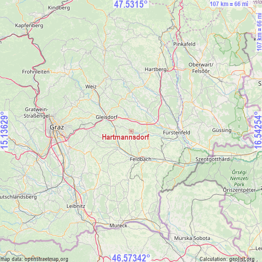
Hartmannsdorf GPS coordinates[2]
47° 3' 16.596" North, 15° 50' 21.876" East
| Map corner | latitude | longitude |
|---|---|---|
| Upper-left | 47.5315°, | 15.13629° |
| Center: | 47.05461°, | 15.83941° |
| Lower-right: | 46.57342°, | 16.54254° |
| Map W x H: | 106.5×106.5 km | = 66.2×66.2mi |
| max Lat: | 48.98333° ⇑81.7% North |
| Hartmannsdorf: | 47.05461° |
| min Lat: | ⇓18.3% South 46.48841° |
| min Long | Hartmannsdorf | max Long |
| 9.57802° | 15.83941° | 17.1° |
| W 75.8%⇐ | ⇒24.2% E |
Elevation
Elevation of Hartmannsdorf is 326 m = 1070 ft, and this is 179.5 m = 589 ft below average elevation for this country.
| Max E: |
2140 m = 7021 ft | 70.3% |
| Avg. | 505.5 m = 1658 ft | |
| Hartmannsdorf | 326 m = 1070 ft | |
Min E: |
118 m = 387 ft | 29.7% |
See also: Austria elevation on elevation.city.
Geographical zone
Hartmannsdorf is located in North temperate zone (between Tropic of Cancer and the Arctic Circle). Distance of this North polar circle is 2169.2 km =1347.9 mi to North.| Distance of | km | miles | from Hartmannsdorf |
|---|---|---|---|
| North Pole | 4775.1 | 2967.1 | to North |
| Arctic Circle | 2169.2 | 1347.9 | to North |
| Tropic Cancer | 2626.1 | 1631.8 | to South |
| Equator | 5232 | 3251 | to South |


Nearby cities:
15 places around Hartmannsdorf: (largest is in red/bold)
• Auersbach
4.7 km =2.9 mi,  153°
153°
• Edelsbach bei Feldbach
7.2 km =4.5 mi,  181°
181°
• Egelsdorf
7.1 km =4.4 mi,  345°
345°
• Fladnitz im Raabtal
8.1 km =5 mi,  210°
210°
• Gnies
5.1 km =3.2 mi,  9°
9°
• Ilz
7.5 km =4.7 mi,  61°
61°
• Mitterfladnitz
5.6 km =3.5 mi, 209°
• Nestelbach im Ilztal
3.8 km =2.4 mi,  32°
32°
• Ottendorf an der Rittschein
4.4 km =2.7 mi,  101°
101°
• Pöllau bei Gleisdorf
3.3 km =2.1 mi,  294°
294°
• Sankt Margarethen an der Raab
6.8 km =4.2 mi,  265°
265°
• Sinabelkirchen
5.3 km =3.3 mi, 350°
• Sulz bei Gleisdorf
8.1 km =5 mi,  279°
279°
• Takern Zwei
6 km =3.7 mi,  246°
246°
• Untergroßau
5.7 km =3.5 mi,  337°
337°
Sources, notices
• [Note1] Compared only with cities in Austria existing in our database
• [Src1] Map data: © OpenStreetMap contributors (CC-BY-SA)
• [Src2] Other city data from geonames.org with taken over terms of usage.
• [Src3] Geographical zone / Annual Mean Temperature by Robert A. Rohde @ Wikipedia
