Untergroßau geodata
Untergroßau (Styria) is a populated place; located in Austria in Europe/Vienna (GMT+2) time zone. With population of 729 people, there are 1775 cities with bigger population in this country. Compared to other cities in Austria, 78.7% of cities are located further ↑North; 74.9% of cities are located further ←West and 71.5% of cities have higher elevation than Untergroßau. Note1
Administrative division(s):
- Level 1: Styria
- Level 2: Politischer Bezirk Weiz
- Level 3: Sinabelkirchen


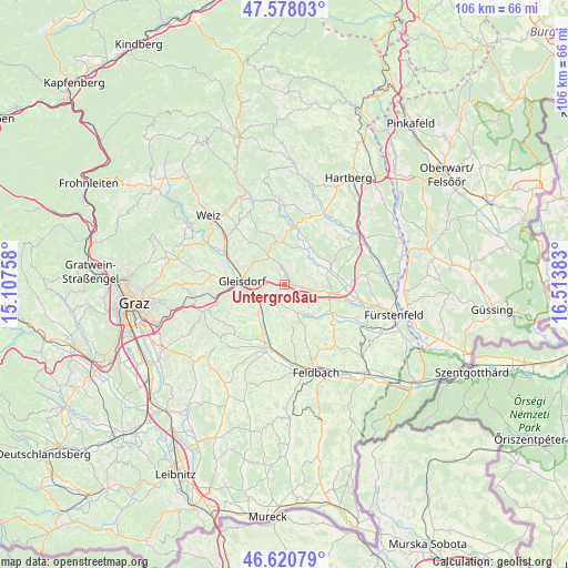
Untergroßau GPS coordinates[2]
47° 6' 5.616" North, 15° 48' 38.52" East
| Map corner | latitude | longitude |
|---|---|---|
| Upper-left | 47.57803°, | 15.10758° |
| Center: | 47.10156°, | 15.8107° |
| Lower-right: | 46.62079°, | 16.51383° |
| Map W x H: | 106.4×106.4 km | = 66.1×66.1mi |
| max Lat: | 48.98333° ⇑78.7% North |
| Untergroßau: | 47.10156° |
| min Lat: | ⇓21.3% South 46.48841° |
| min Long | Untergroßau | max Long |
| 9.57802° | 15.8107° | 17.1° |
| W 74.9%⇐ | ⇒25.1% E |
Elevation
Elevation of Untergroßau is 321 m = 1053 ft, and this is 184.5 m = 605 ft below average elevation for this country.
| Max E: |
2140 m = 7021 ft | 71.5% |
| Avg. | 505.5 m = 1658 ft | |
| Untergroßau | 321 m = 1053 ft | |
Min E: |
118 m = 387 ft | 28.5% |
See also: Austria elevation on elevation.city.
Geographical zone
Untergroßau is located in North temperate zone (between Tropic of Cancer and the Arctic Circle). Distance of this North polar circle is 2164 km =1344.6 mi to North.| Distance of | km | miles | from Untergroßau |
|---|---|---|---|
| North Pole | 4769.9 | 2963.9 | to North |
| Arctic Circle | 2164 | 1344.6 | to North |
| Tropic Cancer | 2631.3 | 1635 | to South |
| Equator | 5237.2 | 3254.2 | to South |


Nearby cities:
15 places around Untergroßau: (largest is in red/bold)
• Egelsdorf
1.7 km =1.1 mi,  15°
15°
• Gleisdorf
7.6 km =4.7 mi,  273°
273°
• Gnies
3 km =1.9 mi,  93°
93°
• Grosssteinbach
7.7 km =4.8 mi,  45°
45°
• Hartmannsdorf
5.7 km =3.5 mi,  157°
157°
• Hofstätten an der Raab
7 km =4.3 mi,  236°
236°
• Nestelbach im Ilztal
4.7 km =2.9 mi,  115°
115°
• Nitscha
4.9 km =3 mi,  290°
290°
• Oberrettenbach
5.4 km =3.4 mi,  351°
351°
• Prebensdorf
4.1 km =2.5 mi,  329°
329°
• Pöllau bei Gleisdorf
4 km =2.5 mi,  191°
191°
• Sankt Margarethen an der Raab
7.3 km =4.5 mi,  218°
218°
• Sinabelkirchen
1.3 km =0.8 mi, 87°
• Sulz bei Gleisdorf
7 km =4.3 mi, 236°
• Wünschendorf
7.1 km =4.4 mi, 268°
Sources, notices
• [Note1] Compared only with cities in Austria existing in our database
• [Src1] Map data: © OpenStreetMap contributors (CC-BY-SA)
• [Src2] Other city data from geonames.org with taken over terms of usage.
• [Src3] Geographical zone / Annual Mean Temperature by Robert A. Rohde @ Wikipedia
