Asperhofen geodata
Asperhofen (Lower Austria) is a seat of a third-order administrative division; located in Austria in Europe/Vienna (GMT+2) time zone. With population of 617 people, there are 2074 cities with bigger population in this country. Compared to other cities in Austria, 82.4% of cities are located further ↓South; 78% of cities are located further ←West and 91% of cities have higher elevation than Asperhofen. Note1
Administrative division(s):
- Level 1: Lower Austria
- Level 2: Politischer Bezirk Sankt Pölten
- Level 3: Asperhofen


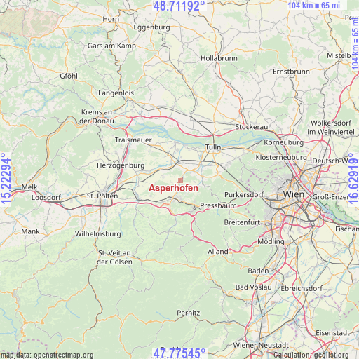
Asperhofen GPS coordinates[2]
48° 14' 44.988" North, 15° 55' 33.816" East
| Map corner | latitude | longitude |
|---|---|---|
| Upper-left | 48.71192°, | 15.22294° |
| Center: | 48.24583°, | 15.92606° |
| Lower-right: | 47.77545°, | 16.62919° |
| Map W x H: | 104.1×104.1 km | = 64.7×64.7mi |
| max Lat: | 48.98333° ⇑17.6% North |
| Asperhofen: | 48.24583° |
| min Lat: | ⇓82.4% South 46.48841° |
| min Long | Asperhofen | max Long |
| 9.57802° | 15.92606° | 17.1° |
| W 78%⇐ | ⇒22% E |
Elevation
Elevation of Asperhofen is 207 m = 679 ft, and this is 298.5 m = 979 ft below average elevation for this country.
| Max E: |
2140 m = 7021 ft | 91% |
| Avg. | 505.5 m = 1658 ft | |
| Asperhofen | 207 m = 679 ft | |
Min E: |
118 m = 387 ft | 9% |
See also: Austria elevation on elevation.city.
Geographical zone
Asperhofen is located in North temperate zone (between Tropic of Cancer and the Arctic Circle). Distance of this North polar circle is 2036.7 km =1265.5 mi to North.| Distance of | km | miles | from Asperhofen |
|---|---|---|---|
| North Pole | 4642.6 | 2884.8 | to North |
| Arctic Circle | 2036.7 | 1265.5 | to North |
| Tropic Cancer | 2758.5 | 1714.1 | to South |
| Equator | 5364.4 | 3333.3 | to South |


Nearby cities:
15 places around Asperhofen: (largest is in red/bold)
• Atzenbrugg
5.3 km =3.3 mi,  343°
343°
• Au am Anzbach
5 km =3.1 mi,  183°
183°
• Ebersberg
6 km =3.7 mi,  205°
205°
• Haag
6.4 km =4 mi,  196°
196°
• Heiligeneich
6.4 km =4 mi, 338°
• Hutten
8.7 km =5.4 mi,  149°
149°
• Judenau
7.5 km =4.7 mi,  54°
54°
• Maria-Anzbach
6.2 km =3.9 mi, 176°
• Michelhausen
5.1 km =3.2 mi,  10°
10°
• Neulengbach
5.7 km =3.5 mi, 198°
• Ottenheim
8.6 km =5.3 mi, 154°
• Sieghartskirchen
6.5 km =4 mi,  80°
80°
• Stein
7.5 km =4.7 mi, 147°
• Trasdorf
8.2 km =5.1 mi,  334°
334°
• Würmla
5 km =3.1 mi,  281°
281°
Sources, notices
• [Note1] Compared only with cities in Austria existing in our database
• [Src1] Map data: © OpenStreetMap contributors (CC-BY-SA)
• [Src2] Other city data from geonames.org with taken over terms of usage.
• [Src3] Geographical zone / Annual Mean Temperature by Robert A. Rohde @ Wikipedia
