Großweikersdorf geodata
Großweikersdorf (Lower Austria) is a seat of a third-order administrative division; located in Austria in Europe/Vienna (GMT+2) time zone. With population of 1,814 people, there are 685 cities with bigger population in this country. Compared to other cities in Austria, 93.5% of cities are located further ↓South; 79.7% of cities are located further ←West and 91.6% of cities have higher elevation than Großweikersdorf. Note1
Administrative division(s):
- Level 1: Lower Austria
- Level 2: Politischer Bezirk Tulln
- Level 3: Großweikersdorf


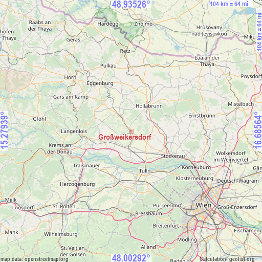
Großweikersdorf GPS coordinates[2]
48° 28' 16.428" North, 15° 58' 57.036" East
| Map corner | latitude | longitude |
|---|---|---|
| Upper-left | 48.93526°, | 15.27939° |
| Center: | 48.47123°, | 15.98251° |
| Lower-right: | 48.00292°, | 16.68564° |
| Map W x H: | 103.7×103.7 km | = 64.4×64.4mi |
| max Lat: | 48.98333° ⇑6.5% North |
| Großweikersdorf: | 48.47123° |
| min Lat: | ⇓93.5% South 46.48841° |
| min Long | Großweikersdor | max Long |
| 9.57802° | 15.98251° | 17.1° |
| W 79.7%⇐ | ⇒20.3% E |
Elevation
Elevation of Großweikersdorf is 204 m = 669 ft, and this is 301.5 m = 989 ft below average elevation for this country.
| Max E: |
2140 m = 7021 ft | 91.6% |
| Avg. | 505.5 m = 1658 ft | |
| Großweikersdorf | 204 m = 669 ft | |
Min E: |
118 m = 387 ft | 8.4% |
See also: Austria elevation on elevation.city.
Geographical zone
Großweikersdorf is located in North temperate zone (between Tropic of Cancer and the Arctic Circle). Distance of this North polar circle is 2011.7 km =1250 mi to North.| Distance of | km | miles | from Großweikersdorf |
|---|---|---|---|
| North Pole | 4617.6 | 2869.2 | to North |
| Arctic Circle | 2011.7 | 1250 | to North |
| Tropic Cancer | 2783.6 | 1729.6 | to South |
| Equator | 5389.5 | 3348.9 | to South |


Nearby cities:
15 places around Großweikersdorf: (largest is in red/bold)
• Absdorf
7.9 km =4.9 mi,  182°
182°
• Breitenwaida
7 km =4.3 mi,  62°
62°
• Fels am Wagram
12.9 km =8 mi,  250°
250°
• Goldgeben
13.9 km =8.6 mi,  134°
134°
• Großriedenthal
8.6 km =5.3 mi,  278°
278°
• Göllersdorf
10.4 km =6.5 mi,  76°
76°
• Hausleiten
13.1 km =8.1 mi,  138°
138°
• Hollabrunn
11.5 km =7.1 mi,  40°
40°
• Kirchberg am Wagram
7.7 km =4.8 mi,  235°
235°
• Niederrußbach
4.4 km =2.7 mi,  122°
122°
• Ravelsbach
13.1 km =8.1 mi,  311°
311°
• Sierndorf
14.3 km =8.9 mi,  108°
108°
• Sonnberg
8.5 km =5.3 mi, 35°
• Stetteldorf am Wagram
7.5 km =4.7 mi,  159°
159°
• Ziersdorf
7.7 km =4.8 mi,  328°
328°
Sources, notices
• [Note1] Compared only with cities in Austria existing in our database
• [Src1] Map data: © OpenStreetMap contributors (CC-BY-SA)
• [Src2] Other city data from geonames.org with taken over terms of usage.
• [Src3] Geographical zone / Annual Mean Temperature by Robert A. Rohde @ Wikipedia
