Breitenwaida geodata
Breitenwaida (Lower Austria) is a populated place; located in Austria in Europe/Vienna (GMT+2) time zone. With population of 782 people, there are 1652 cities with bigger population in this country. Compared to other cities in Austria, 94.3% of cities are located further ↓South; 82.1% of cities are located further ←West and 80.4% of cities have higher elevation than Breitenwaida. Note1
Administrative division(s):
- Level 1: Lower Austria
- Level 2: Politischer Bezirk Hollabrunn
- Level 3: Hollabrunn


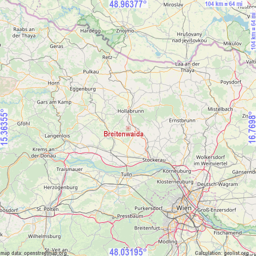
Breitenwaida GPS coordinates[2]
48° 30' 0" North, 16° 4' 0.012" East
| Map corner | latitude | longitude |
|---|---|---|
| Upper-left | 48.96377°, | 15.36355° |
| Center: | 48.5°, | 16.06667° |
| Lower-right: | 48.03195°, | 16.7698° |
| Map W x H: | 103.6×103.6 km | = 64.4×64.4mi |
| max Lat: | 48.98333° ⇑5.7% North |
| Breitenwaida: | 48.5° |
| min Lat: | ⇓94.3% South 46.48841° |
| min Long | Breitenwaida | max Long |
| 9.57802° | 16.06667° | 17.1° |
| W 82.1%⇐ | ⇒17.9% E |
Elevation
Elevation of Breitenwaida is 273 m = 896 ft, and this is 232.5 m = 763 ft below average elevation for this country.
| Max E: |
2140 m = 7021 ft | 80.4% |
| Avg. | 505.5 m = 1658 ft | |
| Breitenwaida | 273 m = 896 ft | |
Min E: |
118 m = 387 ft | 19.6% |
See also: Austria elevation on elevation.city.
Geographical zone
Breitenwaida is located in North temperate zone (between Tropic of Cancer and the Arctic Circle). Distance of this North polar circle is 2008.5 km =1248 mi to North.| Distance of | km | miles | from Breitenwaida |
|---|---|---|---|
| North Pole | 4614.4 | 2867.3 | to North |
| Arctic Circle | 2008.5 | 1248 | to North |
| Tropic Cancer | 2786.8 | 1731.6 | to South |
| Equator | 5392.7 | 3350.9 | to South |


Nearby cities:
15 places around Breitenwaida: (largest is in red/bold)
• Absdorf
12.9 km =8 mi,  210°
210°
• Goldgeben
13.5 km =8.4 mi,  164°
164°
• Großmugl
12.1 km =7.5 mi,  90°
90°
• Großweikersdorf
7 km =4.3 mi,  242°
242°
• Göllersdorf
4 km =2.5 mi,  100°
100°
• Hausleiten
13.2 km =8.2 mi,  169°
169°
• Hollabrunn
5.7 km =3.5 mi,  12°
12°
• Niederrußbach
6.1 km =3.8 mi,  203°
203°
• Schöngrabern
11.2 km =7 mi,  353°
353°
• Sierndorf
10.7 km =6.6 mi,  136°
136°
• Sitzendorf an der Schmida
14.3 km =8.9 mi,  320°
320°
• Sonnberg
3.9 km =2.4 mi,  341°
341°
• Stetteldorf am Wagram
10.8 km =6.7 mi, 199°
• Wullersdorf
14.4 km =8.9 mi, 10°
• Ziersdorf
10.8 km =6.7 mi,  288°
288°
Sources, notices
• [Note1] Compared only with cities in Austria existing in our database
• [Src1] Map data: © OpenStreetMap contributors (CC-BY-SA)
• [Src2] Other city data from geonames.org with taken over terms of usage.
• [Src3] Geographical zone / Annual Mean Temperature by Robert A. Rohde @ Wikipedia
