Groß-Gerungs geodata
Groß-Gerungs (Lower Austria) is a populated place; located in Austria in Europe/Vienna (GMT+2) time zone. With population of 1,121 people, there are 1133 cities with bigger population in this country. Compared to other cities in Austria, 96.1% of cities are located further ↓South; 53.8% of cities are located further ←West and 77.2% of cities have lower elevation than Groß-Gerungs. Note1
Administrative division(s):
- Level 1: Lower Austria
- Level 2: Politischer Bezirk Zwettl
- Level 3: Groß Gerungs


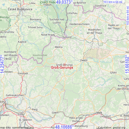
Groß-Gerungs GPS coordinates[2]
48° 34' 27.192" North, 14° 57' 28.404" East
| Map corner | latitude | longitude |
|---|---|---|
| Upper-left | 49.0373°, | 14.25477° |
| Center: | 48.57422°, | 14.95789° |
| Lower-right: | 48.10686°, | 15.66102° |
| Map W x H: | 103.5×103.5 km | = 64.3×64.3mi |
| max Lat: | 48.98333° ⇑3.9% North |
| Groß-Gerungs: | 48.57422° |
| min Lat: | ⇓96.1% South 46.48841° |
| min Long | Groß-Gerungs | max Long |
| 9.57802° | 14.95789° | 17.1° |
| W 53.8%⇐ | ⇒46.2% E |
Elevation
Elevation of Groß-Gerungs is 677 m = 2221 ft, and this is 171.5 m = 563 ft above average elevation for this country.
| Max E: |
2140 m = 7021 ft | 22.8% |
| Groß-Gerungs | 677 m 2221 ft | |
| Avg. | 505.5 m = 1658 ft | |
Min E: |
118 m = 387 ft | 77.2% |
See also: Austria elevation on elevation.city.
Geographical zone
Groß-Gerungs is located in North temperate zone (between Tropic of Cancer and the Arctic Circle). Distance of this North polar circle is 2000.2 km =1242.9 mi to North.| Distance of | km | miles | from Groß-Gerungs |
|---|---|---|---|
| North Pole | 4606.1 | 2862.1 | to North |
| Arctic Circle | 2000.2 | 1242.9 | to North |
| Tropic Cancer | 2795 | 1736.7 | to South |
| Equator | 5400.9 | 3356 | to South |


Nearby cities:
15 places around Groß-Gerungs: (largest is in red/bold)
• Altmelon
12.5 km =7.8 mi,  177°
177°
• Arbesbach
9 km =5.6 mi, 182°
• Bad Traunstein
19.1 km =11.9 mi,  142°
142°
• Dietmanns
17.8 km =11.1 mi,  354°
354°
• Grafenschlag
17.4 km =10.8 mi,  118°
118°
• Grosspertholz
11.6 km =7.2 mi,  301°
301°
• Kirchberg am Walde
19.3 km =12 mi,  29°
29°
• Langschlag
5.4 km =3.4 mi,  270°
270°
• Rappottenstein
10.7 km =6.6 mi, 123°
• Rudmanns
18.5 km =11.5 mi,  80°
80°
• Schweiggers
13 km =8.1 mi,  37°
37°
• Schönbach
14.9 km =9.3 mi,  158°
158°
• Waldenstein
17.6 km =10.9 mi,  13°
13°
• Weitra
15 km =9.3 mi,  338°
338°
• Zwettl Stadt
15.8 km =9.8 mi, 76°
Sources, notices
• [Note1] Compared only with cities in Austria existing in our database
• [Src1] Map data: © OpenStreetMap contributors (CC-BY-SA)
• [Src2] Other city data from geonames.org with taken over terms of usage.
• [Src3] Geographical zone / Annual Mean Temperature by Robert A. Rohde @ Wikipedia
