Ferndorf geodata
Ferndorf (Carinthia) is a seat of a third-order administrative division; located in Austria in Europe/Vienna (GMT+2) time zone. With population of 651 people, there are 1982 cities with bigger population in this country. Compared to other cities in Austria, 94% of cities are located further ↑North; 72.9% of cities are located further →East and 62.3% of cities have lower elevation than Ferndorf. Note1
Administrative division(s):
- Level 1: Carinthia
- Level 2: Politischer Bezirk Villach Land
- Level 3: Ferndorf


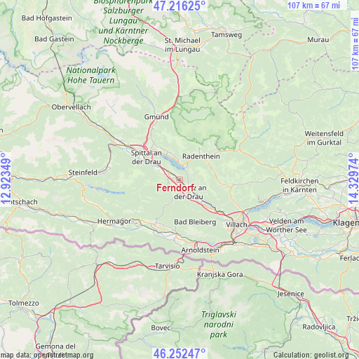
Ferndorf GPS coordinates[2]
46° 44' 11.436" North, 13° 37' 35.796" East
| Map corner | latitude | longitude |
|---|---|---|
| Upper-left | 47.21625°, | 12.92349° |
| Center: | 46.73651°, | 13.62661° |
| Lower-right: | 46.25247°, | 14.32974° |
| Map W x H: | 107.2×107.2 km | = 66.6×66.6mi |
| max Lat: | 48.98333° ⇑94% North |
| Ferndorf: | 46.73651° |
| min Lat: | ⇓6% South 46.48841° |
| min Long | Ferndorf | max Long |
| 9.57802° | 13.62661° | 17.1° |
| W 27.1%⇐ | ⇒72.9% E |
Elevation
Elevation of Ferndorf is 534 m = 1752 ft, and this is 28.5 m = 94 ft above average elevation for this country.
| Max E: |
2140 m = 7021 ft | 37.7% |
| Ferndorf | 534 m 1752 ft | |
| Avg. | 505.5 m = 1658 ft | |
Min E: |
118 m = 387 ft | 62.3% |
See also: Austria elevation on elevation.city.
Geographical zone
Ferndorf is located in North temperate zone (between Tropic of Cancer and the Arctic Circle). Distance of this North polar circle is 2204.6 km =1369.9 mi to North.| Distance of | km | miles | from Ferndorf |
|---|---|---|---|
| North Pole | 4810.4 | 2989 | to North |
| Arctic Circle | 2204.6 | 1369.9 | to North |
| Tropic Cancer | 2590.7 | 1609.8 | to South |
| Equator | 5196.6 | 3229 | to South |


Nearby cities:
15 places around Ferndorf: (largest is in red/bold)
• Bleiberg-Kreuth
11.6 km =7.2 mi,  176°
176°
• Döbriach
5.4 km =3.4 mi,  25°
25°
• Feistritz an der Drau
4.9 km =3 mi,  143°
143°
• Feld am See
10.2 km =6.3 mi,  64°
64°
• Fresach
5.4 km =3.4 mi,  115°
115°
• Kaning
11.9 km =7.4 mi, 31°
• Millstatt
8.3 km =5.2 mi,  335°
335°
• Neu-Feffernitz
6.7 km =4.2 mi, 143°
• Nikelsdorf
3.7 km =2.3 mi,  156°
156°
• Obermillstatt
8.8 km =5.5 mi,  347°
347°
• Paternion
2.6 km =1.6 mi, 163°
• Radenthein
9.6 km =6 mi,  42°
42°
• Stockenboi
8 km =5 mi,  261°
261°
• Untertweng
10.2 km =6.3 mi,  54°
54°
• Weissenstein
9.7 km =6 mi,  125°
125°
Sources, notices
• [Note1] Compared only with cities in Austria existing in our database
• [Src1] Map data: © OpenStreetMap contributors (CC-BY-SA)
• [Src2] Other city data from geonames.org with taken over terms of usage.
• [Src3] Geographical zone / Annual Mean Temperature by Robert A. Rohde @ Wikipedia
