Radenthein geodata
Radenthein (Carinthia) is a seat of a third-order administrative division; located in Austria in Europe/Vienna (GMT+2) time zone. With population of 1,846 people, there are 672 cities with bigger population in this country. Compared to other cities in Austria, 91.9% of cities are located further ↑North; 71.1% of cities are located further →East and 80.2% of cities have lower elevation than Radenthein. Note1
Administrative division(s):
- Level 1: Carinthia
- Level 2: Politischer Bezirk Spittal an der Drau
- Level 3: Radenthein


Radenthein GPS coordinates[2]
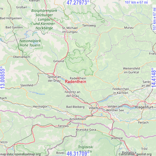
46° 48' 2.016" North, 13° 42' 42.012" East
| Map corner | latitude | longitude |
|---|---|---|
| Upper-left | 47.27973°, | 13.00855° |
| Center: | 46.80056°, | 13.71167° |
| Lower-right: | 46.31709°, | 14.4148° |
| Map W x H: | 107×107 km | = 66.5×66.5mi |
| max Lat: | 48.98333° ⇑91.9% North |
| Radenthein: | 46.80056° |
| min Lat: | ⇓8.1% South 46.48841° |
| min Long | Radenthein | max Long |
| 9.57802° | 13.71167° | 17.1° |
| W 28.9%⇐ | ⇒71.1% E |
Elevation
Elevation of Radenthein is 722 m = 2369 ft, and this is 216.5 m = 710 ft above average elevation for this country.
| Max E: |
2140 m = 7021 ft | 19.8% |
| Radenthein | 722 m 2369 ft | |
| Avg. | 505.5 m = 1658 ft | |
Min E: |
118 m = 387 ft | 80.2% |
See also: Austria elevation on elevation.city.
Geographical zone
Radenthein is located in North temperate zone (between Tropic of Cancer and the Arctic Circle). Distance of this North polar circle is 2197.4 km =1365.4 mi to North.| Distance of | km | miles | from Radenthein |
|---|---|---|---|
| North Pole | 4803.3 | 2984.6 | to North |
| Arctic Circle | 2197.4 | 1365.4 | to North |
| Tropic Cancer | 2597.8 | 1614.2 | to South |
| Equator | 5203.7 | 3233.4 | to South |


Nearby cities:
15 places around Radenthein: (largest is in red/bold)
• Arriach
13.2 km =8.2 mi,  126°
126°
• Bad Kleinkirchheim
5.5 km =3.4 mi,  72°
72°
• Döbriach
4.7 km =2.9 mi,  241°
241°
• Feistritz an der Drau
11.6 km =7.2 mi,  197°
197°
• Feld am See
3.8 km =2.4 mi, 134°
• Ferndorf
9.6 km =6 mi,  222°
222°
• Fresach
9.6 km =6 mi,  189°
189°
• Kaning
3 km =1.9 mi,  356°
356°
• Millstatt
10 km =6.2 mi,  272°
272°
• Neu-Feffernitz
12.8 km =8 mi, 191°
• Nikelsdorf
11.6 km =7.2 mi,  205°
205°
• Obermillstatt
8.5 km =5.3 mi,  280°
280°
• Paternion
11.2 km =7 mi, 210°
• Untertweng
2.2 km =1.4 mi,  122°
122°
• Weissenstein
12.8 km =8 mi,  173°
173°
Sources, notices
• [Note1] Compared only with cities in Austria existing in our database
• [Src1] Map data: © OpenStreetMap contributors (CC-BY-SA)
• [Src2] Other city data from geonames.org with taken over terms of usage.
• [Src3] Geographical zone / Annual Mean Temperature by Robert A. Rohde @ Wikipedia
