Raabau geodata
Raabau (Styria) is a seat of a third-order administrative division; located in Austria in Europe/Vienna (GMT+2) time zone. With population of 602 people, there are 2134 cities with bigger population in this country. Compared to other cities in Austria, 85.8% of cities are located further ↑North; 77.8% of cities are located further ←West and 77% of cities have higher elevation than Raabau. Note1
Administrative division(s):
- Level 1: Styria
- Level 2: Politischer Bezirk Südoststeiermark
- Level 3: Feldbach


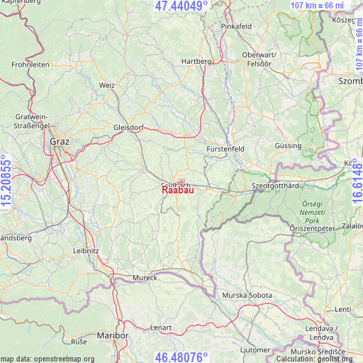
Raabau GPS coordinates[2]
46° 57' 46.008" North, 15° 54' 42.012" East
| Map corner | latitude | longitude |
|---|---|---|
| Upper-left | 47.44049°, | 15.20855° |
| Center: | 46.96278°, | 15.91167° |
| Lower-right: | 46.48076°, | 16.6148° |
| Map W x H: | 106.7×106.7 km | = 66.3×66.3mi |
| max Lat: | 48.98333° ⇑85.8% North |
| Raabau: | 46.96278° |
| min Lat: | ⇓14.2% South 46.48841° |
| min Long | Raabau | max Long |
| 9.57802° | 15.91167° | 17.1° |
| W 77.8%⇐ | ⇒22.2% E |
Elevation
Elevation of Raabau is 289 m = 948 ft, and this is 216.5 m = 710 ft below average elevation for this country.
| Max E: |
2140 m = 7021 ft | 77% |
| Avg. | 505.5 m = 1658 ft | |
| Raabau | 289 m = 948 ft | |
Min E: |
118 m = 387 ft | 23% |
See also: Austria elevation on elevation.city.
Geographical zone
Raabau is located in North temperate zone (between Tropic of Cancer and the Arctic Circle). Distance of this North polar circle is 2179.4 km =1354.2 mi to North.| Distance of | km | miles | from Raabau |
|---|---|---|---|
| North Pole | 4785.3 | 2973.4 | to North |
| Arctic Circle | 2179.4 | 1354.2 | to North |
| Tropic Cancer | 2615.9 | 1625.4 | to South |
| Equator | 5221.8 | 3244.7 | to South |


Nearby cities:
15 places around Raabau: (largest is in red/bold)
• Auersbach
6.9 km =4.3 mi,  330°
330°
• Edelsbach bei Feldbach
6.4 km =4 mi,  297°
297°
• Fehring
7.7 km =4.8 mi,  109°
109°
• Feldbach
2.1 km =1.3 mi,  238°
238°
• Gniebing
4.2 km =2.6 mi,  269°
269°
• Gossendorf
6 km =3.7 mi,  166°
166°
• Hatzendorf
7 km =4.3 mi,  77°
77°
• Leitersdorf im Raabtal
2.9 km =1.8 mi,  144°
144°
• Lödersdorf
2.4 km =1.5 mi,  100°
100°
• Lödersdorf I
3 km =1.9 mi, 97°
• Mühldorf bei Feldbach
2.7 km =1.7 mi,  186°
186°
• Oedt bei Feldbach
4.6 km =2.9 mi,  230°
230°
• Pertlstein
4.5 km =2.8 mi,  123°
123°
• Riegersburg
4.4 km =2.7 mi,  18°
18°
• Unterweissenbach
4.9 km =3 mi,  253°
253°
Sources, notices
• [Note1] Compared only with cities in Austria existing in our database
• [Src1] Map data: © OpenStreetMap contributors (CC-BY-SA)
• [Src2] Other city data from geonames.org with taken over terms of usage.
• [Src3] Geographical zone / Annual Mean Temperature by Robert A. Rohde @ Wikipedia
