Bad Erlach geodata
Bad Erlach (Lower Austria) is a seat of a third-order administrative division; located in Austria in Europe/Vienna (GMT+2) time zone. With population of 2,651 people, there are 442 cities with bigger population in this country. Compared to other cities in Austria, 54.7% of cities are located further ↓South; 86.4% of cities are located further ←West and 73.7% of cities have higher elevation than Bad Erlach. Note1
Administrative division(s):
- Level 1: Lower Austria
- Level 2: Politischer Bezirk Wiener Neustadt
- Level 3: Bad Erlach


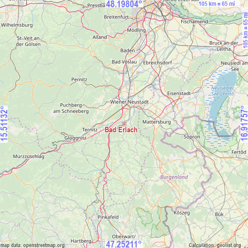
Bad Erlach GPS coordinates[2]
47° 43' 37.992" North, 16° 12' 51.984" East
| Map corner | latitude | longitude |
|---|---|---|
| Upper-left | 48.19804°, | 15.51132° |
| Center: | 47.72722°, | 16.21444° |
| Lower-right: | 47.25211°, | 16.91757° |
| Map W x H: | 105.2×105.2 km | = 65.4×65.4mi |
| max Lat: | 48.98333° ⇑45.3% North |
| Bad Erlach: | 47.72722° |
| min Lat: | ⇓54.7% South 46.48841° |
| min Long | Bad Erlach | max Long |
| 9.57802° | 16.21444° | 17.1° |
| W 86.4%⇐ | ⇒13.6% E |
Elevation
Elevation of Bad Erlach is 310 m = 1017 ft, and this is 195.5 m = 641 ft below average elevation for this country.
| Max E: |
2140 m = 7021 ft | 73.7% |
| Avg. | 505.5 m = 1658 ft | |
| Bad Erlach | 310 m = 1017 ft | |
Min E: |
118 m = 387 ft | 26.3% |
See also: Austria elevation on elevation.city.
Geographical zone
Bad Erlach is located in North temperate zone (between Tropic of Cancer and the Arctic Circle). Distance of this North polar circle is 2094.4 km =1301.4 mi to North.| Distance of | km | miles | from Bad Erlach |
|---|---|---|---|
| North Pole | 4700.3 | 2920.6 | to North |
| Arctic Circle | 2094.4 | 1301.4 | to North |
| Tropic Cancer | 2700.9 | 1678.3 | to South |
| Equator | 5306.8 | 3297.5 | to South |


Nearby cities:
15 places around Bad Erlach: (largest is in red/bold)
• Breitenau
5.4 km =3.4 mi,  277°
277°
• Bromberg
6.9 km =4.3 mi,  182°
182°
• Frohsdorf
2.7 km =1.7 mi,  75°
75°
• Haderswörth
2.7 km =1.7 mi, 75°
• Hochwolkersdorf
8.9 km =5.5 mi,  145°
145°
• Katzelsdorf
7.2 km =4.5 mi,  34°
34°
• Kleinwolkersdorf
3.7 km =2.3 mi,  46°
46°
• Lanzenkirchen
1.1 km =0.7 mi,  22°
22°
• Loipersbach
7.4 km =4.6 mi,  260°
260°
• Peisching
7.6 km =4.7 mi,  268°
268°
• Pitten
2.6 km =1.6 mi,  243°
243°
• Schwarzau am Steinfeld
3.3 km =2.1 mi, 278°
• Seebenstein
6.1 km =3.8 mi, 239°
• Walpersbach
1.8 km =1.1 mi,  129°
129°
• Wiener Neustadt
8.7 km =5.4 mi,  8°
8°
Sources, notices
• [Note1] Compared only with cities in Austria existing in our database
• [Src1] Map data: © OpenStreetMap contributors (CC-BY-SA)
• [Src2] Other city data from geonames.org with taken over terms of usage.
• [Src3] Geographical zone / Annual Mean Temperature by Robert A. Rohde @ Wikipedia
