Droß geodata
Droß (Lower Austria) is a seat of a third-order administrative division; located in Austria in Europe/Vienna (GMT+2) time zone. With population of 959 people, there are 1349 cities with bigger population in this country. Compared to other cities in Austria, 93.1% of cities are located further ↓South; 67.8% of cities are located further ←West and 61.4% of cities have higher elevation than Droß. Note1


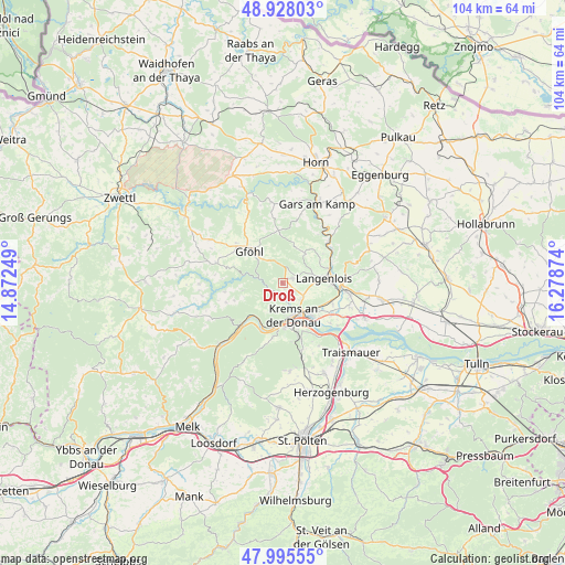
Droß GPS coordinates[2]
48° 27' 50.148" North, 15° 34' 32.196" East
| Map corner | latitude | longitude |
|---|---|---|
| Upper-left | 48.92803°, | 14.87249° |
| Center: | 48.46393°, | 15.57561° |
| Lower-right: | 47.99555°, | 16.27874° |
| Map W x H: | 103.7×103.7 km | = 64.4×64.4mi |
| max Lat: | 48.98333° ⇑6.9% North |
| Droß: | 48.46393° |
| min Lat: | ⇓93.1% South 46.48841° |
| min Long | Droß | max Long |
| 9.57802° | 15.57561° | 17.1° |
| W 67.8%⇐ | ⇒32.2% E |
Elevation
Elevation of Droß is 374 m = 1227 ft, and this is 131.5 m = 431 ft below average elevation for this country.
| Max E: |
2140 m = 7021 ft | 61.4% |
| Avg. | 505.5 m = 1658 ft | |
| Droß | 374 m = 1227 ft | |
Min E: |
118 m = 387 ft | 38.6% |
See also: Austria elevation on elevation.city.
Geographical zone
Droß is located in North temperate zone (between Tropic of Cancer and the Arctic Circle). Distance of this North polar circle is 2012.5 km =1250.5 mi to North.| Distance of | km | miles | from Droß |
|---|---|---|---|
| North Pole | 4618.4 | 2869.7 | to North |
| Arctic Circle | 2012.5 | 1250.5 | to North |
| Tropic Cancer | 2782.8 | 1729.2 | to South |
| Equator | 5388.7 | 3348.4 | to South |


Nearby cities:
15 places around Droß: (largest is in red/bold)
• Egelsee
5.3 km =3.3 mi,  190°
190°
• Gneixendorf
4.3 km =2.7 mi,  133°
133°
• Imbach
1.7 km =1.1 mi,  159°
159°
• Krems an der Donau
6.7 km =4.2 mi,  154°
154°
• Landersdorf
6.8 km =4.2 mi,  140°
140°
• Langenlois
6.7 km =4.2 mi,  87°
87°
• Lengenfeld
1.9 km =1.2 mi,  62°
62°
• Lerchenfeld
7.1 km =4.4 mi, 144°
• Rehberg
3.7 km =2.3 mi,  167°
167°
• Rohrendorf bei Krems
7.8 km =4.8 mi, 129°
• Schiltern
6.6 km =4.1 mi,  27°
27°
• Senftenberg
3.9 km =2.4 mi,  209°
209°
• Stein an der Donau
6.9 km =4.3 mi,  176°
176°
• Stratzing
2.4 km =1.5 mi, 130°
• Weinzierl bei Krems
7.3 km =4.5 mi, 165°
Sources, notices
• [Note1] Compared only with cities in Austria existing in our database
• [Src1] Map data: © OpenStreetMap contributors (CC-BY-SA)
• [Src2] Other city data from geonames.org with taken over terms of usage.
• [Src3] Geographical zone / Annual Mean Temperature by Robert A. Rohde @ Wikipedia
