Bizau geodata
Bizau (Vorarlberg) is a seat of a third-order administrative division; located in Austria in Europe/Vienna (GMT+2) time zone. With population of 1,107 people, there are 1152 cities with bigger population in this country. Compared to other cities in Austria, 61.4% of cities are located further ↑North; 97.3% of cities are located further →East and 77.6% of cities have lower elevation than Bizau. Note1


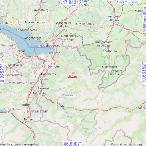
Bizau GPS coordinates[2]
47° 22' 8.616" North, 9° 55' 42.204" East
| Map corner | latitude | longitude |
|---|---|---|
| Upper-left | 47.84312°, | 9.22527° |
| Center: | 47.36906°, | 9.92839° |
| Lower-right: | 46.8907°, | 10.63152° |
| Map W x H: | 105.9×105.9 km | = 65.8×65.8mi |
| max Lat: | 48.98333° ⇑61.4% North |
| Bizau: | 47.36906° |
| min Lat: | ⇓38.6% South 46.48841° |
| min Long | Bizau | max Long |
| 9.57802° | 9.92839° | 17.1° |
| W 2.7%⇐ | ⇒97.3% E |
Elevation
Elevation of Bizau is 682 m = 2238 ft, and this is 176.5 m = 579 ft above average elevation for this country.
| Max E: |
2140 m = 7021 ft | 22.4% |
| Bizau | 682 m 2238 ft | |
| Avg. | 505.5 m = 1658 ft | |
Min E: |
118 m = 387 ft | 77.6% |
See also: Austria elevation on elevation.city.
Geographical zone
Bizau is located in North temperate zone (between Tropic of Cancer and the Arctic Circle). Distance of this North polar circle is 2134.2 km =1326.1 mi to North.| Distance of | km | miles | from Bizau |
|---|---|---|---|
| North Pole | 4740.1 | 2945.4 | to North |
| Arctic Circle | 2134.2 | 1326.1 | to North |
| Tropic Cancer | 2661 | 1653.5 | to South |
| Equator | 5266.9 | 3272.7 | to South |


Nearby cities:
15 places around Bizau: (largest is in red/bold)
• Andelsbuch
5.4 km =3.4 mi,  330°
330°
• Au
6.6 km =4.1 mi,  143°
143°
• Bezau
2.7 km =1.7 mi,  310°
310°
• Damüls
10.2 km =6.3 mi,  195°
195°
• Egg
7.3 km =4.5 mi,  341°
341°
• Großdorf
7.2 km =4.5 mi,  352°
352°
• Hittisau
10.1 km =6.3 mi,  13°
13°
• Lingenau
9.1 km =5.7 mi,  356°
356°
• Mellau
4.1 km =2.5 mi,  239°
239°
• Rehmen
7.4 km =4.6 mi, 135°
• Reuthe
2.5 km =1.6 mi,  275°
275°
• Schnepfau
2.3 km =1.4 mi,  146°
146°
• Schoppernau
9.2 km =5.7 mi,  133°
133°
• Schwarzenberg
7.7 km =4.8 mi, 310°
• Sibratsgfäll
10.4 km =6.5 mi,  52°
52°
Sources, notices
• [Note1] Compared only with cities in Austria existing in our database
• [Src1] Map data: © OpenStreetMap contributors (CC-BY-SA)
• [Src2] Other city data from geonames.org with taken over terms of usage.
• [Src3] Geographical zone / Annual Mean Temperature by Robert A. Rohde @ Wikipedia
