Haid geodata
Haid (Salzburg) is a populated place; located in Austria in Europe/Vienna (GMT+2) time zone. With population of 521 people, there are 2427 cities with bigger population in this country. Compared to other cities in Austria, 59.1% of cities are located further ↑North; 84.4% of cities are located further →East and 82.3% of cities have lower elevation than Haid. Note1
Administrative division(s):
- Level 1: Salzburg
- Level 2: Politischer Bezirk Zell am See
- Level 3: Saalfelden am Steinernen Meer


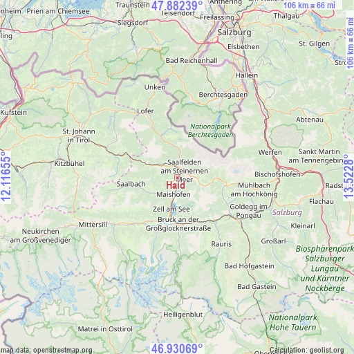
Haid GPS coordinates[2]
47° 24' 31.284" North, 12° 49' 10.812" East
| Map corner | latitude | longitude |
|---|---|---|
| Upper-left | 47.88239°, | 12.11655° |
| Center: | 47.40869°, | 12.81967° |
| Lower-right: | 46.93069°, | 13.5228° |
| Map W x H: | 105.8×105.8 km | = 65.7×65.7mi |
| max Lat: | 48.98333° ⇑59.1% North |
| Haid: | 47.40869° |
| min Lat: | ⇓40.9% South 46.48841° |
| min Long | Haid | max Long |
| 9.57802° | 12.81967° | 17.1° |
| W 15.6%⇐ | ⇒84.4% E |
Elevation
Elevation of Haid is 756 m = 2480 ft, and this is 250.5 m = 822 ft above average elevation for this country.
| Max E: |
2140 m = 7021 ft | 17.7% |
| Haid | 756 m 2480 ft | |
| Avg. | 505.5 m = 1658 ft | |
Min E: |
118 m = 387 ft | 82.3% |
See also: Austria elevation on elevation.city.
Geographical zone
Haid is located in North temperate zone (between Tropic of Cancer and the Arctic Circle). Distance of this North polar circle is 2129.8 km =1323.4 mi to North.| Distance of | km | miles | from Haid |
|---|---|---|---|
| North Pole | 4735.7 | 2942.6 | to North |
| Arctic Circle | 2129.8 | 1323.4 | to North |
| Tropic Cancer | 2665.4 | 1656.2 | to South |
| Equator | 5271.4 | 3275.5 | to South |


Nearby cities:
15 places around Haid: (largest is in red/bold)
• Atzing
5.9 km =3.7 mi,  194°
194°
• Bsuch
1.6 km =1 mi,  120°
120°
• Dorfheim
3 km =1.9 mi,  24°
24°
• Lenzing
4.3 km =2.7 mi,  355°
355°
• Leogang
5.6 km =3.5 mi,  307°
307°
• Maishofen
4.9 km =3 mi,  197°
197°
• Maria Alm am Steinernen Meer
6.1 km =3.8 mi,  93°
93°
• Mitterhofen
3.2 km =2 mi,  207°
207°
• Ramseiden
4.2 km =2.6 mi,  66°
66°
• Saalfelden am Steinernen Meer
2.9 km =1.8 mi,  46°
46°
• Sonnberg
8 km =5 mi, 305°
• Thor
2.3 km =1.4 mi, 51°
• Thumersbach
8.8 km =5.5 mi,  181°
181°
• Viehhofen
8 km =5 mi,  234°
234°
• Zell am See
9.4 km =5.8 mi, 191°
Sources, notices
• [Note1] Compared only with cities in Austria existing in our database
• [Src1] Map data: © OpenStreetMap contributors (CC-BY-SA)
• [Src2] Other city data from geonames.org with taken over terms of usage.
• [Src3] Geographical zone / Annual Mean Temperature by Robert A. Rohde @ Wikipedia
