Hart geodata
Hart (Lower Austria) is a populated place; located in Austria in Europe/Vienna (GMT+2) time zone. With population of 1,194 people, there are 1052 cities with bigger population in this country. Compared to other cities in Austria, 75.9% of cities are located further ↓South; 69.2% of cities are located further ←West and 76.4% of cities have higher elevation than Hart. Note1


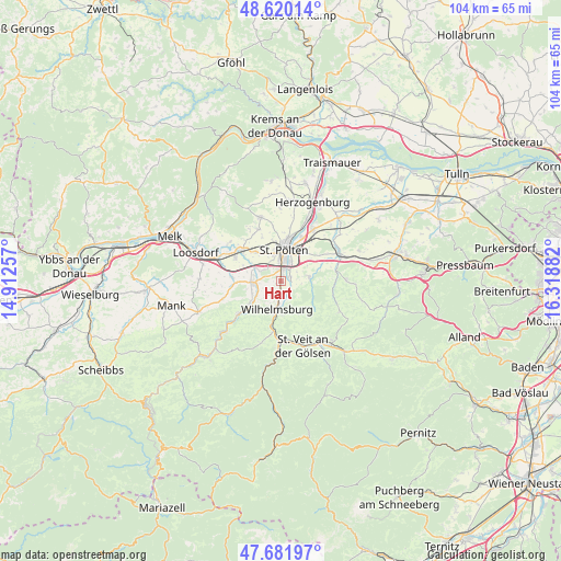
Hart GPS coordinates[2]
48° 9' 11.52" North, 15° 36' 56.484" East
| Map corner | latitude | longitude |
|---|---|---|
| Upper-left | 48.62014°, | 14.91257° |
| Center: | 48.1532°, | 15.61569° |
| Lower-right: | 47.68197°, | 16.31882° |
| Map W x H: | 104.3×104.3 km | = 64.8×64.8mi |
| max Lat: | 48.98333° ⇑24.1% North |
| Hart: | 48.1532° |
| min Lat: | ⇓75.9% South 46.48841° |
| min Long | Hart | max Long |
| 9.57802° | 15.61569° | 17.1° |
| W 69.2%⇐ | ⇒30.8% E |
Elevation
Elevation of Hart is 294 m = 965 ft, and this is 211.5 m = 694 ft below average elevation for this country.
| Max E: |
2140 m = 7021 ft | 76.4% |
| Avg. | 505.5 m = 1658 ft | |
| Hart | 294 m = 965 ft | |
Min E: |
118 m = 387 ft | 23.6% |
See also: Austria elevation on elevation.city.
Geographical zone
Hart is located in North temperate zone (between Tropic of Cancer and the Arctic Circle). Distance of this North polar circle is 2047 km =1271.9 mi to North.| Distance of | km | miles | from Hart |
|---|---|---|---|
| North Pole | 4652.9 | 2891.2 | to North |
| Arctic Circle | 2047 | 1271.9 | to North |
| Tropic Cancer | 2748.2 | 1707.7 | to South |
| Equator | 5354.1 | 3326.9 | to South |


Nearby cities:
15 places around Hart: (largest is in red/bold)
• Eggendorf
2.5 km =1.6 mi,  173°
173°
• Gerersdorf
6.9 km =4.3 mi,  320°
320°
• Harland
1.9 km =1.2 mi,  60°
60°
• Mühlgang
1.4 km =0.9 mi,  180°
180°
• Ober-Grafendorf
5.2 km =3.2 mi,  266°
266°
• Oberwagram
5.9 km =3.7 mi,  24°
24°
• Pyhra
5.3 km =3.3 mi,  82°
82°
• Sankt Pölten
5.4 km =3.4 mi,  14°
14°
• Spratzern
1.9 km =1.2 mi, 6°
• Stattersdorf
3.6 km =2.2 mi, 21°
• Teufelhof
3.4 km =2.1 mi,  1°
1°
• Unterwagram
7 km =4.3 mi, 20°
• Viehofen
7.1 km =4.4 mi, 0°
• Weinburg
7.6 km =4.7 mi,  234°
234°
• Wilhelmsburg
5.3 km =3.3 mi,  188°
188°
Sources, notices
• [Note1] Compared only with cities in Austria existing in our database
• [Src1] Map data: © OpenStreetMap contributors (CC-BY-SA)
• [Src2] Other city data from geonames.org with taken over terms of usage.
• [Src3] Geographical zone / Annual Mean Temperature by Robert A. Rohde @ Wikipedia
