Orroroo geodata
Orroroo (South Australia) is a populated place; located in Australia in Australia/Adelaide (GMT+10.5) time zone. With population of 628 people, there are 4495 cities with bigger population in this country. Compared to other cities in Australia, 60.2% of cities are located further ↓South; 80.9% of cities are located further →East and 91.5% of cities have lower elevation than Orroroo. Note1


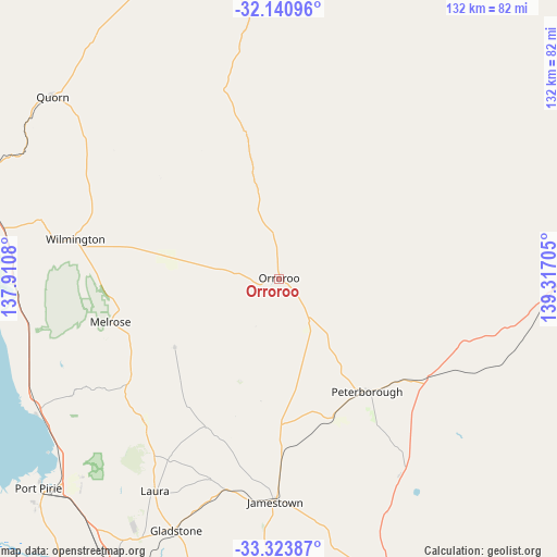
Orroroo GPS coordinates[2]
32° 44' 3.768" South, 138° 36' 50.112" East
| Map corner | latitude | longitude |
|---|---|---|
| Upper-left | -32.14096°, | 137.9108° |
| Center: | -32.73438°, | 138.61392° |
| Lower-right: | -33.32387°, | 139.31705° |
| Map W x H: | 131.5×131.5 km | = 81.7×81.7mi |
| max Lat: | -10.58257° ⇑39.8% North |
| Orroroo: | -32.73438° |
| min Lat: | ⇓60.2% South -43.31423° |
| min Long | Orroroo | max Long |
| 113.53327° | 138.61392° | 153.61246° |
| W 19.1%⇐ | ⇒80.9% E |
Elevation
Elevation of Orroroo is 429 m = 1407 ft, and this is 307 m = 1007 ft above average elevation for this country.
| Max E: |
1715 m = 5627 ft | 8.5% |
| Orroroo | 429 m 1407 ft | |
| Avg. | 122 m = 400 ft | |
Min E: |
-2 m = -7 ft | 91.5% |
See also: Australia elevation on elevation.city.
Geographical zone
Orroroo is located in South temperate zone (between Tropic of Capricorn and the Antarctic Circle). Distance of this Southern Tropic circle is 1033.8 km =642.4 mi to North.| Distance of | km | miles | from Orroroo |
|---|---|---|---|
| Equator | 3639.7 | 2261.6 | to North |
| Tropic Capricorn | 1033.8 | 642.4 | to North |
| Antarctic Circle | 3761.5 | 2337.3 | to South |
| South Pole | 6367.3 | 3956.5 | to South |


Nearby cities:
15 places around Orroroo: (largest is in red/bold)
• Crystal Brook
78.4 km =48.7 mi,  208°
208°
• Gladstone
63.9 km =39.7 mi,  202°
202°
• Jamestown
52.4 km =32.6 mi,  180°
180°
• Laura
57.9 km =36 mi, 210°
• Napperby
66.1 km =41.1 mi,  224°
224°
• Peterborough
33.9 km =21.1 mi,  141°
141°
• Port Pirie
75.4 km =46.9 mi,  227°
227°
• Port Pirie South
76.1 km =47.3 mi, 227°
• Port Pirie West
75.7 km =47 mi, 229°
• Quorn
68.8 km =42.8 mi,  308°
308°
• Risdon Park
77.4 km =48.1 mi, 228°
• Risdon Park South
78.4 km =48.7 mi, 227°
• Solomontown
74.5 km =46.3 mi, 227°
• Stirling North
78 km =48.5 mi,  291°
291°
• Wilmington
49.2 km =30.6 mi,  281°
281°
Sources, notices
• [Note1] Compared only with cities in Australia existing in our database
• [Src1] Map data: © OpenStreetMap contributors (CC-BY-SA)
• [Src2] Other city data from geonames.org with taken over terms of usage.
• [Src3] Geographical zone / Annual Mean Temperature by Robert A. Rohde @ Wikipedia
