Mallala geodata
Mallala (South Australia) is a populated place; located in Australia in Australia/Adelaide (GMT+10.5) time zone. With population of 866 people, there are 4028 cities with bigger population in this country. Compared to other cities in Australia, 62.7% of cities are located further ↑North; 84.3% of cities are located further →East and 51.1% of cities have lower elevation than Mallala. Note1


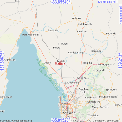
Mallala GPS coordinates[2]
34° 26' 14.64" South, 138° 30' 35.532" East
| Map corner | latitude | longitude |
|---|---|---|
| Upper-left | -33.85549°, | 137.80675° |
| Center: | -34.4374°, | 138.50987° |
| Lower-right: | -35.01528°, | 139.213° |
| Map W x H: | 129×129 km | = 80.2×80.2mi |
| max Lat: | -10.58257° ⇑62.7% North |
| Mallala: | -34.4374° |
| min Lat: | ⇓37.3% South -43.31423° |
| min Long | Mallala | max Long |
| 113.53327° | 138.50987° | 153.61246° |
| W 15.7%⇐ | ⇒84.3% E |
Elevation
Elevation of Mallala is 47 m = 154 ft, and this is 75 m = 246 ft below average elevation for this country.
| Max E: |
1715 m = 5627 ft | 48.9% |
| Avg. | 122 m = 400 ft | |
| Mallala | 47 m = 154 ft | |
Min E: |
-2 m = -7 ft | 51.1% |
See also: Australia elevation on elevation.city.
Geographical zone
Mallala is located in South temperate zone (between Tropic of Capricorn and the Antarctic Circle). Distance of this Southern Tropic circle is 1223.2 km =760.1 mi to North.| Distance of | km | miles | from Mallala |
|---|---|---|---|
| Equator | 3829.1 | 2379.3 | to North |
| Tropic Capricorn | 1223.2 | 760.1 | to North |
| Antarctic Circle | 3572.1 | 2219.6 | to South |
| South Pole | 6178 | 3838.8 | to South |


Nearby cities:
15 places around Mallala: (largest is in red/bold)
• Angle Vale
25.8 km =16 mi,  151°
151°
• Evanston Gardens
28.3 km =17.6 mi,  136°
136°
• Freeling
27.5 km =17.1 mi,  93°
93°
• Gawler West
27.6 km =17.1 mi,  132°
132°
• Gawler city centre
27.8 km =17.3 mi, 129°
• Hamley Bridge
18 km =11.2 mi,  60°
60°
• Hewett
27.2 km =16.9 mi, 125°
• Hillier
25.9 km =16.1 mi, 146°
• Lewiston
20 km =12.4 mi,  158°
158°
• MacDonald Park
27.5 km =17.1 mi, 153°
• Roseworthy
24.5 km =15.2 mi,  115°
115°
• Two Wells
17.3 km =10.7 mi,  178°
178°
• Virginia
25.9 km =16.1 mi,  169°
169°
• Wasleys
16.5 km =10.3 mi,  102°
102°
• Willaston
26.9 km =16.7 mi, 128°
Sources, notices
• [Note1] Compared only with cities in Australia existing in our database
• [Src1] Map data: © OpenStreetMap contributors (CC-BY-SA)
• [Src2] Other city data from geonames.org with taken over terms of usage.
• [Src3] Geographical zone / Annual Mean Temperature by Robert A. Rohde @ Wikipedia
