Serpentine geodata
Serpentine (Western Australia) is a section of populated place; located in Australia in Australia/Perth (GMT+8) time zone. With population of 2,266 people, there are 2718 cities with bigger population in this country. Compared to other cities in Australia, 62% of cities are located further ↓South; 92.7% of cities are located further →East and 56.9% of cities have higher elevation than Serpentine. Note1


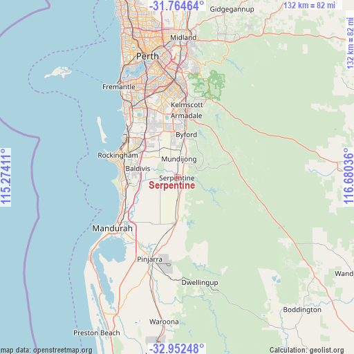
Serpentine GPS coordinates[2]
32° 21' 37.836" South, 115° 58' 38.028" East
| Map corner | latitude | longitude |
|---|---|---|
| Upper-left | -31.76464°, | 115.27411° |
| Center: | -32.36051°, | 115.97723° |
| Lower-right: | -32.95248°, | 116.68036° |
| Map W x H: | 132.1×132.1 km | = 82.1×82.1mi |
| max Lat: | -10.58257° ⇑38% North |
| Serpentine: | -32.36051° |
| min Lat: | ⇓62% South -43.31423° |
| min Long | Serpentine | max Long |
| 113.53327° | 115.97723° | 153.61246° |
| W 7.3%⇐ | ⇒92.7% E |
Elevation
Elevation of Serpentine is 36 m = 118 ft, and this is 86 m = 282 ft below average elevation for this country.
| Max E: |
1715 m = 5627 ft | 56.9% |
| Avg. | 122 m = 400 ft | |
| Serpentine | 36 m = 118 ft | |
Min E: |
-2 m = -7 ft | 43.1% |
See also: Australia elevation on elevation.city.
Geographical zone
Serpentine is located in South temperate zone (between Tropic of Capricorn and the Antarctic Circle). Distance of this Southern Tropic circle is 992.2 km =616.5 mi to North.| Distance of | km | miles | from Serpentine |
|---|---|---|---|
| Equator | 3598.2 | 2235.8 | to North |
| Tropic Capricorn | 992.2 | 616.5 | to North |
| Antarctic Circle | 3803 | 2363.1 | to South |
| South Pole | 6408.9 | 3982.3 | to South |


Nearby cities:
15 places around Serpentine: (largest is in red/bold)
• Baldivis
14.2 km =8.8 mi,  284°
284°
• Bertram
17.9 km =11.1 mi,  316°
316°
• Byford
15.8 km =9.8 mi,  10°
10°
• Cardup
11.4 km =7.1 mi,  3°
3°
• Casuarina
16.7 km =10.4 mi, 322°
• Cooloongup
19.4 km =12.1 mi,  285°
285°
• Darling Downs
18.5 km =11.5 mi, 4°
• Jarrahdale
8.2 km =5.1 mi,  70°
70°
• Karnup
18.5 km =11.5 mi,  249°
249°
• Keysbrook
8.2 km =5.1 mi,  186°
186°
• Mundijong
7.6 km =4.7 mi, 5°
• North Dandalup
17.4 km =10.8 mi,  181°
181°
• Oakford
18.2 km =11.3 mi,  347°
347°
• Parmelia
18.5 km =11.5 mi,  308°
308°
• Wellard
17.1 km =10.6 mi, 307°
Sources, notices
• [Note1] Compared only with cities in Australia existing in our database
• [Src1] Map data: © OpenStreetMap contributors (CC-BY-SA)
• [Src2] Other city data from geonames.org with taken over terms of usage.
• [Src3] Geographical zone / Annual Mean Temperature by Robert A. Rohde @ Wikipedia
