Freeling geodata
Freeling (South Australia) is a populated place; located in Australia in Australia/Adelaide (GMT+10.5) time zone. With population of 2,204 people, there are 2755 cities with bigger population in this country. Compared to other cities in Australia, 62.9% of cities are located further ↑North; 77.3% of cities are located further →East and 80.9% of cities have lower elevation than Freeling. Note1


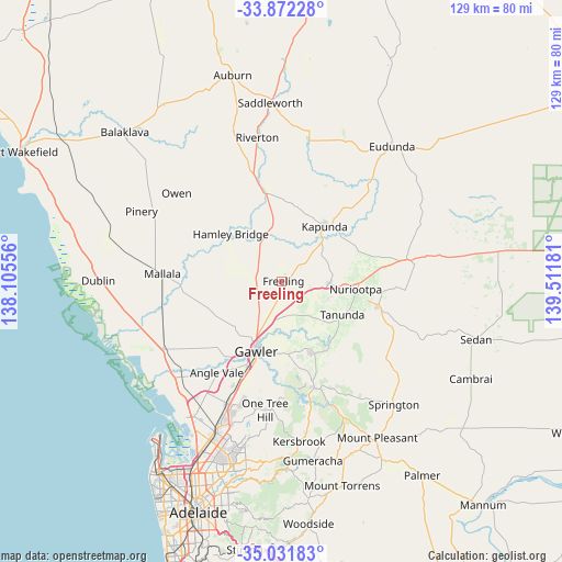
Freeling GPS coordinates[2]
34° 27' 14.652" South, 138° 48' 31.248" East
| Map corner | latitude | longitude |
|---|---|---|
| Upper-left | -33.87228°, | 138.10556° |
| Center: | -34.45407°, | 138.80868° |
| Lower-right: | -35.03183°, | 139.51181° |
| Map W x H: | 128.9×128.9 km | = 80.1×80.1mi |
| max Lat: | -10.58257° ⇑62.9% North |
| Freeling: | -34.45407° |
| min Lat: | ⇓37.1% South -43.31423° |
| min Long | Freeling | max Long |
| 113.53327° | 138.80868° | 153.61246° |
| W 22.7%⇐ | ⇒77.3% E |
Elevation
Elevation of Freeling is 192 m = 630 ft, and this is 70 m = 230 ft above average elevation for this country.
| Max E: |
1715 m = 5627 ft | 19.1% |
| Freeling | 192 m 630 ft | |
| Avg. | 122 m = 400 ft | |
Min E: |
-2 m = -7 ft | 80.9% |
See also: Australia elevation on elevation.city.
Geographical zone
Freeling is located in South temperate zone (between Tropic of Capricorn and the Antarctic Circle). Distance of this Southern Tropic circle is 1225 km =761.2 mi to North.| Distance of | km | miles | from Freeling |
|---|---|---|---|
| Equator | 3830.9 | 2380.4 | to North |
| Tropic Capricorn | 1225 | 761.2 | to North |
| Antarctic Circle | 3570.2 | 2218.4 | to South |
| South Pole | 6176.1 | 3837.6 | to South |


Nearby cities:
15 places around Freeling: (largest is in red/bold)
• Gawler
17.4 km =10.8 mi,  198°
198°
• Gawler East
16.6 km =10.3 mi,  194°
194°
• Gawler South
18 km =11.2 mi, 199°
• Gawler West
18.1 km =11.2 mi, 202°
• Gawler city centre
16.9 km =10.5 mi, 200°
• Greenock
10.9 km =6.8 mi,  91°
91°
• Hamley Bridge
15.9 km =9.9 mi,  312°
312°
• Hewett
14.7 km =9.1 mi, 200°
• Kapunda
16.2 km =10.1 mi,  37°
37°
• Lyndoch
18 km =11.2 mi,  155°
155°
• Nuriootpa
17.4 km =10.8 mi,  95°
95°
• Roseworthy
10.4 km =6.5 mi,  211°
211°
• Tanunda
15.8 km =9.8 mi,  119°
119°
• Wasleys
11.4 km =7.1 mi,  261°
261°
• Willaston
16 km =9.9 mi, 202°
Sources, notices
• [Note1] Compared only with cities in Australia existing in our database
• [Src1] Map data: © OpenStreetMap contributors (CC-BY-SA)
• [Src2] Other city data from geonames.org with taken over terms of usage.
• [Src3] Geographical zone / Annual Mean Temperature by Robert A. Rohde @ Wikipedia
