Pingelly geodata
Pingelly (Western Australia) is a populated place; located in Australia in Australia/Perth (GMT+8) time zone. With population of 795 people, there are 4160 cities with bigger population in this country. Compared to other cities in Australia, 61.4% of cities are located further ↓South; 90.6% of cities are located further →East and 87.8% of cities have lower elevation than Pingelly. Note1


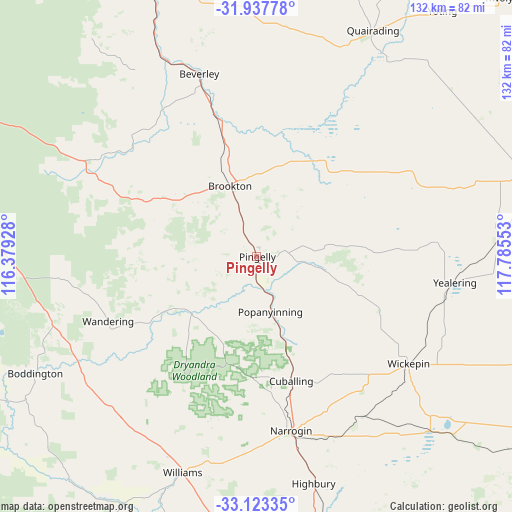
Pingelly GPS coordinates[2]
32° 31' 57.072" South, 117° 4' 56.64" East
| Map corner | latitude | longitude |
|---|---|---|
| Upper-left | -31.93778°, | 116.37928° |
| Center: | -32.53252°, | 117.0824° |
| Lower-right: | -33.12335°, | 117.78553° |
| Map W x H: | 131.8×131.8 km | = 81.9×81.9mi |
| max Lat: | -10.58257° ⇑38.6% North |
| Pingelly: | -32.53252° |
| min Lat: | ⇓61.4% South -43.31423° |
| min Long | Pingelly | max Long |
| 113.53327° | 117.0824° | 153.61246° |
| W 9.4%⇐ | ⇒90.6% E |
Elevation
Elevation of Pingelly is 308 m = 1010 ft, and this is 186 m = 610 ft above average elevation for this country.
| Max E: |
1715 m = 5627 ft | 12.2% |
| Pingelly | 308 m 1010 ft | |
| Avg. | 122 m = 400 ft | |
Min E: |
-2 m = -7 ft | 87.8% |
See also: Australia elevation on elevation.city.
Geographical zone
Pingelly is located in South temperate zone (between Tropic of Capricorn and the Antarctic Circle). Distance of this Southern Tropic circle is 1011.4 km =628.5 mi to North.| Distance of | km | miles | from Pingelly |
|---|---|---|---|
| Equator | 3617.3 | 2247.7 | to North |
| Tropic Capricorn | 1011.4 | 628.5 | to North |
| Antarctic Circle | 3783.9 | 2351.2 | to South |
| South Pole | 6389.8 | 3970.4 | to South |


Nearby cities:
15 places around Pingelly: (largest is in red/bold)
• Bedfordale
104.8 km =65.1 mi,  292°
292°
• Beverley
49.4 km =30.7 mi,  342°
342°
• Boddington
64.2 km =39.9 mi,  242°
242°
• Brookton
19 km =11.8 mi, 339°
• Corrigin
77.3 km =48 mi,  73°
73°
• Cunderdin
98.7 km =61.3 mi,  8°
8°
• Dwellingup
97.7 km =60.7 mi,  258°
258°
• Jarrahdale
98.5 km =61.2 mi,  282°
282°
• Narrogin
45.4 km =28.2 mi,  168°
168°
• North Dandalup
104.1 km =64.7 mi,  270°
270°
• Pickering Brook
99 km =61.5 mi,  302°
302°
• Quairading
64.9 km =40.3 mi,  26°
26°
• Wagin
89.7 km =55.7 mi,  164°
164°
• Williams
58.3 km =36.2 mi,  199°
199°
• York
77.5 km =48.2 mi, 337°
Sources, notices
• [Note1] Compared only with cities in Australia existing in our database
• [Src1] Map data: © OpenStreetMap contributors (CC-BY-SA)
• [Src2] Other city data from geonames.org with taken over terms of usage.
• [Src3] Geographical zone / Annual Mean Temperature by Robert A. Rohde @ Wikipedia
