Boddington geodata
Boddington (Western Australia) is a populated place; located in Australia in Australia/Perth (GMT+8) time zone. With population of 1,153 people, there are 3638 cities with bigger population in this country. Compared to other cities in Australia, 59.7% of cities are located further ↓South; 90.9% of cities are located further →East and 83.1% of cities have lower elevation than Boddington. Note1


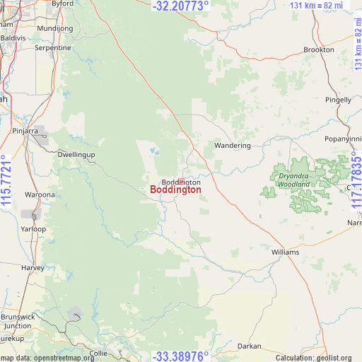
Boddington GPS coordinates[2]
32° 48' 2.556" South, 116° 28' 30.792" East
| Map corner | latitude | longitude |
|---|---|---|
| Upper-left | -32.20773°, | 115.7721° |
| Center: | -32.80071°, | 116.47522° |
| Lower-right: | -33.38976°, | 117.17835° |
| Map W x H: | 131.4×131.4 km | = 81.6×81.6mi |
| max Lat: | -10.58257° ⇑40.3% North |
| Boddington: | -32.80071° |
| min Lat: | ⇓59.7% South -43.31423° |
| min Long | Boddington | max Long |
| 113.53327° | 116.47522° | 153.61246° |
| W 9.1%⇐ | ⇒90.9% E |
Elevation
Elevation of Boddington is 219 m = 719 ft, and this is 97 m = 318 ft above average elevation for this country.
| Max E: |
1715 m = 5627 ft | 16.9% |
| Boddington | 219 m 719 ft | |
| Avg. | 122 m = 400 ft | |
Min E: |
-2 m = -7 ft | 83.1% |
See also: Australia elevation on elevation.city.
Geographical zone
Boddington is located in South temperate zone (between Tropic of Capricorn and the Antarctic Circle). Distance of this Southern Tropic circle is 1041.2 km =647 mi to North.| Distance of | km | miles | from Boddington |
|---|---|---|---|
| Equator | 3647.1 | 2266.2 | to North |
| Tropic Capricorn | 1041.2 | 647 | to North |
| Antarctic Circle | 3754.1 | 2332.7 | to South |
| South Pole | 6360 | 3951.9 | to South |


Nearby cities:
15 places around Boddington: (largest is in red/bold)
• Allanson
69 km =42.9 mi,  210°
210°
• Cookernup
59.4 km =36.9 mi,  249°
249°
• Dwellingup
39.8 km =24.7 mi,  283°
283°
• Harvey
60.7 km =37.7 mi,  239°
239°
• Jarrahdale
64.7 km =40.2 mi,  322°
322°
• Keysbrook
62.7 km =39 mi,  310°
310°
• Narrogin
67.2 km =41.8 mi,  102°
102°
• North Dandalup
56.7 km =35.2 mi,  303°
303°
• North Yunderup
68.4 km =42.5 mi,  291°
291°
• Pingelly
64.2 km =39.9 mi,  62°
62°
• Pinjarra
59.4 km =36.9 mi, 288°
• Ravenswood
64.9 km =40.3 mi, 291°
• Serpentine
67.6 km =42 mi, 316°
• Waroona
51.9 km =32.2 mi,  264°
264°
• Williams
45.4 km =28.2 mi,  123°
123°
Sources, notices
• [Note1] Compared only with cities in Australia existing in our database
• [Src1] Map data: © OpenStreetMap contributors (CC-BY-SA)
• [Src2] Other city data from geonames.org with taken over terms of usage.
• [Src3] Geographical zone / Annual Mean Temperature by Robert A. Rohde @ Wikipedia
