Beverley geodata
Beverley (Western Australia) is a populated place; located in Australia in Australia/Perth (GMT+8) time zone. With population of 1,115 people, there are 3679 cities with bigger population in this country. Compared to other cities in Australia, 63.5% of cities are located further ↓South; 90.6% of cities are located further →East and 81.6% of cities have lower elevation than Beverley. Note1


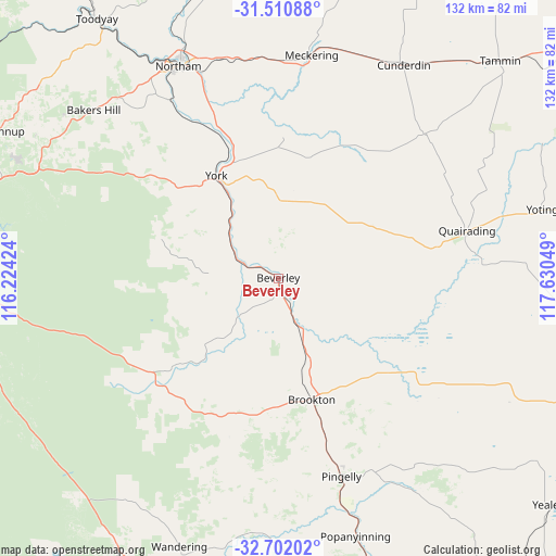
Beverley GPS coordinates[2]
32° 6' 30.204" South, 116° 55' 38.496" East
| Map corner | latitude | longitude |
|---|---|---|
| Upper-left | -31.51088°, | 116.22424° |
| Center: | -32.10839°, | 116.92736° |
| Lower-right: | -32.70202°, | 117.63049° |
| Map W x H: | 132.4×132.4 km | = 82.3×82.3mi |
| max Lat: | -10.58257° ⇑36.5% North |
| Beverley: | -32.10839° |
| min Lat: | ⇓63.5% South -43.31423° |
| min Long | Beverley | max Long |
| 113.53327° | 116.92736° | 153.61246° |
| W 9.4%⇐ | ⇒90.6% E |
Elevation
Elevation of Beverley is 200 m = 656 ft, and this is 78 m = 256 ft above average elevation for this country.
| Max E: |
1715 m = 5627 ft | 18.4% |
| Beverley | 200 m 656 ft | |
| Avg. | 122 m = 400 ft | |
Min E: |
-2 m = -7 ft | 81.6% |
See also: Australia elevation on elevation.city.
Geographical zone
Beverley is located in South temperate zone (between Tropic of Capricorn and the Antarctic Circle). Distance of this Southern Tropic circle is 964.2 km =599.1 mi to North.| Distance of | km | miles | from Beverley |
|---|---|---|---|
| Equator | 3570.1 | 2218.4 | to North |
| Tropic Capricorn | 964.2 | 599.1 | to North |
| Antarctic Circle | 3831.1 | 2380.5 | to South |
| South Pole | 6436.9 | 3999.7 | to South |


Nearby cities:
15 places around Beverley: (largest is in red/bold)
• Bakers Hill
59.8 km =37.2 mi,  312°
312°
• Brookton
30.4 km =18.9 mi,  165°
165°
• Chidlow
67.6 km =42 mi,  294°
294°
• Cunderdin
58.2 km =36.2 mi,  29°
29°
• Mount Helena
72.4 km =45 mi, 290°
• Mundaring
75.2 km =46.7 mi, 287°
• Northam
56.4 km =35 mi,  334°
334°
• Pickering Brook
69 km =42.9 mi,  275°
275°
• Pingelly
49.4 km =30.7 mi,  162°
162°
• Quairading
45.4 km =28.2 mi,  76°
76°
• Sawyers Valley
72.2 km =44.9 mi, 288°
• Stoneville
75.8 km =47.1 mi, 289°
• Wooroloo
67.1 km =41.7 mi,  300°
300°
• Wundowie
64.5 km =40.1 mi, 306°
• York
28.7 km =17.8 mi, 328°
Sources, notices
• [Note1] Compared only with cities in Australia existing in our database
• [Src1] Map data: © OpenStreetMap contributors (CC-BY-SA)
• [Src2] Other city data from geonames.org with taken over terms of usage.
• [Src3] Geographical zone / Annual Mean Temperature by Robert A. Rohde @ Wikipedia
