York geodata
York (Western Australia) is a populated place; located in Australia in Australia/Perth (GMT+8) time zone. With population of 2,472 people, there are 2594 cities with bigger population in this country. Compared to other cities in Australia, 67% of cities are located further ↓South; 90.8% of cities are located further →East and 79.8% of cities have lower elevation than York. Note1


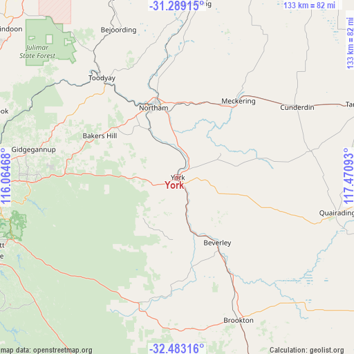
York GPS coordinates[2]
31° 53' 17.124" South, 116° 46' 4.08" East
| Map corner | latitude | longitude |
|---|---|---|
| Upper-left | -31.28915°, | 116.06468° |
| Center: | -31.88809°, | 116.7678° |
| Lower-right: | -32.48316°, | 117.47093° |
| Map W x H: | 132.8×132.8 km | = 82.5×82.5mi |
| max Lat: | -10.58257° ⇑33% North |
| York: | -31.88809° |
| min Lat: | ⇓67% South -43.31423° |
| min Long | York | max Long |
| 113.53327° | 116.7678° | 153.61246° |
| W 9.2%⇐ | ⇒90.8% E |
Elevation
Elevation of York is 179 m = 587 ft, and this is 57 m = 187 ft above average elevation for this country.
| Max E: |
1715 m = 5627 ft | 20.2% |
| York | 179 m 587 ft | |
| Avg. | 122 m = 400 ft | |
Min E: |
-2 m = -7 ft | 79.8% |
See also: Australia elevation on elevation.city.
Geographical zone
York is located in South temperate zone (between Tropic of Capricorn and the Antarctic Circle). Distance of this Southern Tropic circle is 939.7 km =583.9 mi to North.| Distance of | km | miles | from York |
|---|---|---|---|
| Equator | 3545.6 | 2203.1 | to North |
| Tropic Capricorn | 939.7 | 583.9 | to North |
| Antarctic Circle | 3855.6 | 2395.8 | to South |
| South Pole | 6461.4 | 4014.9 | to South |


Nearby cities:
15 places around York: (largest is in red/bold)
• Bakers Hill
33.2 km =20.6 mi,  298°
298°
• Beverley
28.7 km =17.8 mi,  148°
148°
• Chidlow
46.9 km =29.1 mi,  273°
273°
• Coondle
55.5 km =34.5 mi,  324°
324°
• Cunderdin
51.2 km =31.8 mi,  59°
59°
• Morangup
51.2 km =31.8 mi, 298°
• Mount Helena
52.7 km =32.7 mi, 271°
• Northam
28 km =17.4 mi,  341°
341°
• Pickering Brook
56.6 km =35.2 mi,  251°
251°
• Sawyers Valley
53.6 km =33.3 mi, 268°
• Stoneville
56.4 km =35 mi, 271°
• Toodyay
47.1 km =29.3 mi, 322°
• West Toodyay
51.6 km =32.1 mi, 319°
• Wooroloo
44 km =27.3 mi,  282°
282°
• Wundowie
39.3 km =24.4 mi,  290°
290°
Sources, notices
• [Note1] Compared only with cities in Australia existing in our database
• [Src1] Map data: © OpenStreetMap contributors (CC-BY-SA)
• [Src2] Other city data from geonames.org with taken over terms of usage.
• [Src3] Geographical zone / Annual Mean Temperature by Robert A. Rohde @ Wikipedia
