Morawa geodata
Morawa (Western Australia) is a populated place; located in Australia in Australia/Perth (GMT+8) time zone. With population of 596 people, there are 4580 cities with bigger population in this country. Compared to other cities in Australia, 73% of cities are located further ↓South; 92.3% of cities are located further →East and 86.7% of cities have lower elevation than Morawa. Note1


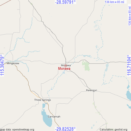
Morawa GPS coordinates[2]
29° 12' 48.348" South, 116° 0' 28.476" East
| Map corner | latitude | longitude |
|---|---|---|
| Upper-left | -28.59791°, | 115.30479° |
| Center: | -29.21343°, | 116.00791° |
| Lower-right: | -29.82528°, | 116.71104° |
| Map W x H: | 136.5×136.5 km | = 84.8×84.8mi |
| max Lat: | -10.58257° ⇑27% North |
| Morawa: | -29.21343° |
| min Lat: | ⇓73% South -43.31423° |
| min Long | Morawa | max Long |
| 113.53327° | 116.00791° | 153.61246° |
| W 7.7%⇐ | ⇒92.3% E |
Elevation
Elevation of Morawa is 280 m = 919 ft, and this is 158 m = 518 ft above average elevation for this country.
| Max E: |
1715 m = 5627 ft | 13.3% |
| Morawa | 280 m 919 ft | |
| Avg. | 122 m = 400 ft | |
Min E: |
-2 m = -7 ft | 86.7% |
See also: Australia elevation on elevation.city.
Geographical zone
Morawa is located in South temperate zone (between Tropic of Capricorn and the Antarctic Circle). Distance of this Southern Tropic circle is 642.3 km =399.1 mi to North.| Distance of | km | miles | from Morawa |
|---|---|---|---|
| Equator | 3248.2 | 2018.3 | to North |
| Tropic Capricorn | 642.3 | 399.1 | to North |
| Antarctic Circle | 4152.9 | 2580.5 | to South |
| South Pole | 6758.8 | 4199.7 | to South |


Nearby cities:
15 places around Morawa: (largest is in red/bold)
• Dalwallinu
134.3 km =83.5 mi,  152°
152°
• Deepdale
136.2 km =84.6 mi,  290°
290°
• Dongara
104.4 km =64.9 mi,  267°
267°
• Karloo
141 km =87.6 mi, 289°
• Melville
134.6 km =83.6 mi,  31°
31°
• Moresby
140.4 km =87.2 mi, 292°
• Mount Tarcoola
142.1 km =88.3 mi, 288°
• Mullewa
89.2 km =55.4 mi,  327°
327°
• Port Denison
105.7 km =65.7 mi, 266°
• Rangeway
142.1 km =88.3 mi, 289°
• Tarcoola Beach
142 km =88.2 mi, 288°
• Utakarra
140.4 km =87.2 mi, 289°
• Wandina
140.5 km =87.3 mi, 288°
• Woorree
140.4 km =87.2 mi, 290°
• Yalgoo
116.9 km =72.6 mi, 34°
Sources, notices
• [Note1] Compared only with cities in Australia existing in our database
• [Src1] Map data: © OpenStreetMap contributors (CC-BY-SA)
• [Src2] Other city data from geonames.org with taken over terms of usage.
• [Src3] Geographical zone / Annual Mean Temperature by Robert A. Rohde @ Wikipedia
