Dalwallinu geodata
Dalwallinu (Western Australia) is a populated place; located in Australia in Australia/Perth (GMT+8) time zone. With population of 814 people, there are 4116 cities with bigger population in this country. Compared to other cities in Australia, 71.9% of cities are located further ↓South; 90.9% of cities are located further →East and 88.9% of cities have lower elevation than Dalwallinu. Note1


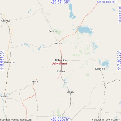
Dalwallinu GPS coordinates[2]
30° 16' 49.62" South, 116° 39' 36.54" East
| Map corner | latitude | longitude |
|---|---|---|
| Upper-left | -29.67138°, | 115.95703° |
| Center: | -30.28045°, | 116.66015° |
| Lower-right: | -30.88576°, | 117.36328° |
| Map W x H: | 135×135 km | = 83.9×83.9mi |
| max Lat: | -10.58257° ⇑28.1% North |
| Dalwallinu: | -30.28045° |
| min Lat: | ⇓71.9% South -43.31423° |
| min Long | Dalwallinu | max Long |
| 113.53327° | 116.66015° | 153.61246° |
| W 9.1%⇐ | ⇒90.9% E |
Elevation
Elevation of Dalwallinu is 343 m = 1125 ft, and this is 221 m = 725 ft above average elevation for this country.
| Max E: |
1715 m = 5627 ft | 11.1% |
| Dalwallinu | 343 m 1125 ft | |
| Avg. | 122 m = 400 ft | |
Min E: |
-2 m = -7 ft | 88.9% |
See also: Australia elevation on elevation.city.
Geographical zone
Dalwallinu is located in South temperate zone (between Tropic of Capricorn and the Antarctic Circle). Distance of this Southern Tropic circle is 761 km =472.9 mi to North.| Distance of | km | miles | from Dalwallinu |
|---|---|---|---|
| Equator | 3366.9 | 2092.1 | to North |
| Tropic Capricorn | 761 | 472.9 | to North |
| Antarctic Circle | 4034.3 | 2506.8 | to South |
| South Pole | 6640.2 | 4126 | to South |


Nearby cities:
15 places around Dalwallinu: (largest is in red/bold)
• Bindoon
134.2 km =83.4 mi,  203°
203°
• Cervantes
154.7 km =96.1 mi,  261°
261°
• Chittering
143.1 km =88.9 mi, 202°
• Coondle
135.4 km =84.1 mi,  189°
189°
• Gingin
138.8 km =86.2 mi,  211°
211°
• Goomalling
114.6 km =71.2 mi,  172°
172°
• Lancelin
151.1 km =93.9 mi,  236°
236°
• Lower Chittering
153.9 km =95.6 mi, 199°
• Moora
74.5 km =46.3 mi, 237°
• Morawa
134.3 km =83.5 mi,  332°
332°
• Northam
152.2 km =94.6 mi,  179°
179°
• Toodyay
142.3 km =88.4 mi, 187°
• West Toodyay
141.2 km =87.7 mi, 189°
• Wongan Hills
68.3 km =42.4 mi, 175°
• Woodridge
155.1 km =96.4 mi,  220°
220°
Sources, notices
• [Note1] Compared only with cities in Australia existing in our database
• [Src1] Map data: © OpenStreetMap contributors (CC-BY-SA)
• [Src2] Other city data from geonames.org with taken over terms of usage.
• [Src3] Geographical zone / Annual Mean Temperature by Robert A. Rohde @ Wikipedia
