Kingscote geodata
Kingscote (South Australia) is a populated place; located in Australia in Australia/Adelaide (GMT+10.5) time zone. With population of 1,816 people, there are 3034 cities with bigger population in this country. Compared to other cities in Australia, 77.5% of cities are located further ↑North; 85.7% of cities are located further →East and 81.9% of cities have higher elevation than Kingscote. Note1


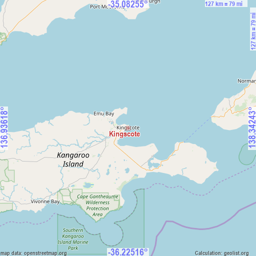
Kingscote GPS coordinates[2]
35° 39' 21.24" South, 137° 38' 21.48" East
| Map corner | latitude | longitude |
|---|---|---|
| Upper-left | -35.08255°, | 136.93618° |
| Center: | -35.6559°, | 137.6393° |
| Lower-right: | -36.22516°, | 138.34243° |
| Map W x H: | 127×127 km | = 78.9×78.9mi |
| max Lat: | -10.58257° ⇑77.5% North |
| Kingscote: | -35.6559° |
| min Lat: | ⇓22.5% South -43.31423° |
| min Long | Kingscote | max Long |
| 113.53327° | 137.6393° | 153.61246° |
| W 14.3%⇐ | ⇒85.7% E |
Elevation
Elevation of Kingscote is 14 m = 46 ft, and this is 108 m = 354 ft below average elevation for this country.
| Max E: |
1715 m = 5627 ft | 81.9% |
| Avg. | 122 m = 400 ft | |
| Kingscote | 14 m = 46 ft | |
Min E: |
-2 m = -7 ft | 18.1% |
See also: Australia elevation on elevation.city.
Geographical zone
Kingscote is located in South temperate zone (between Tropic of Capricorn and the Antarctic Circle). Distance of this Southern Tropic circle is 1358.6 km =844.2 mi to North.| Distance of | km | miles | from Kingscote |
|---|---|---|---|
| Equator | 3964.6 | 2463.5 | to North |
| Tropic Capricorn | 1358.6 | 844.2 | to North |
| Antarctic Circle | 3436.6 | 2135.4 | to South |
| South Pole | 6042.5 | 3754.6 | to South |


Nearby cities:
15 places around Kingscote: (largest is in red/bold)
• Aldinga
86.9 km =54 mi,  61°
61°
• Aldinga Beach
85.2 km =52.9 mi, 60°
• Encounter Bay
87.4 km =54.3 mi,  84°
84°
• Honiton
60 km =37.3 mi,  0°
0°
• Maslin Beach
89.9 km =55.9 mi, 57°
• McCracken
90.7 km =56.4 mi, 81°
• Moana
91.6 km =56.9 mi, 55°
• Myponga
80.3 km =49.9 mi,  69°
69°
• Normanville
66 km =41 mi, 69°
• Port Willunga
86.6 km =53.8 mi, 59°
• Sellicks Beach
81.2 km =50.5 mi, 64°
• Stansbury
84.1 km =52.3 mi,  9°
9°
• Victor Harbor
89.6 km =55.7 mi, 82°
• Yankalilla
68 km =42.3 mi, 71°
• Yorketown
70.9 km =44.1 mi,  357°
357°
Sources, notices
• [Note1] Compared only with cities in Australia existing in our database
• [Src1] Map data: © OpenStreetMap contributors (CC-BY-SA)
• [Src2] Other city data from geonames.org with taken over terms of usage.
• [Src3] Geographical zone / Annual Mean Temperature by Robert A. Rohde @ Wikipedia
