Honiton geodata
Honiton (South Australia) is a seat of a second-order administrative division; located in Australia in Australia/Adelaide (GMT+10.5) time zone. In our database, there are 4878 cities with bigger population. Compared to other cities in Australia, 73.2% of cities are located further ↑North; 85.6% of cities are located further →East and 77.5% of cities have higher elevation than Honiton. Note1


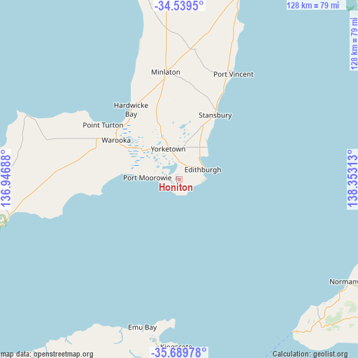
Honiton GPS coordinates[2]
35° 7' 0.012" South, 137° 39' 0" East
| Map corner | latitude | longitude |
|---|---|---|
| Upper-left | -34.5395°, | 136.94688° |
| Center: | -35.11667°, | 137.65° |
| Lower-right: | -35.68978°, | 138.35313° |
| Map W x H: | 127.9×127.9 km | = 79.5×79.5mi |
| max Lat: | -10.58257° ⇑73.2% North |
| Honiton: | -35.11667° |
| min Lat: | ⇓26.8% South -43.31423° |
| min Long | Honiton | max Long |
| 113.53327° | 137.65° | 153.61246° |
| W 14.4%⇐ | ⇒85.6% E |
Elevation
Elevation of Honiton is 17 m = 56 ft, and this is 105 m = 344 ft below average elevation for this country.
| Max E: |
1715 m = 5627 ft | 77.5% |
| Avg. | 122 m = 400 ft | |
| Honiton | 17 m = 56 ft | |
Min E: |
-2 m = -7 ft | 22.5% |
See also: Australia elevation on elevation.city.
Geographical zone
Honiton is located in South temperate zone (between Tropic of Capricorn and the Antarctic Circle). Distance of this Southern Tropic circle is 1298.7 km =807 mi to North.| Distance of | km | miles | from Honiton |
|---|---|---|---|
| Equator | 3904.6 | 2426.2 | to North |
| Tropic Capricorn | 1298.7 | 807 | to North |
| Antarctic Circle | 3496.6 | 2172.7 | to South |
| South Pole | 6102.5 | 3791.9 | to South |


Nearby cities:
15 places around Honiton: (largest is in red/bold)
• Aldinga Beach
75.6 km =47 mi,  103°
103°
• Christies Beach
74.8 km =46.5 mi,  91°
91°
• Kingscote
60 km =37.3 mi,  180°
180°
• Minlaton
38.8 km =24.1 mi,  352°
352°
• Moana
75.6 km =47 mi, 96°
• Normanville
71.1 km =44.2 mi,  121°
121°
• O'Sullivan Beach
74.9 km =46.5 mi, 90°
• Port Noarlunga
74.7 km =46.4 mi, 92°
• Port Noarlunga South
74.7 km =46.4 mi, 94°
• Port Willunga
75.7 km =47 mi, 102°
• Seaford
75.5 km =46.9 mi, 96°
• Seaford Rise
76.1 km =47.3 mi, 96°
• Stansbury
26.6 km =16.5 mi,  30°
30°
• Yankalilla
73.9 km =45.9 mi, 120°
• Yorketown
11.7 km =7.3 mi,  339°
339°
Sources, notices
• [Note1] Compared only with cities in Australia existing in our database
• [Src1] Map data: © OpenStreetMap contributors (CC-BY-SA)
• [Src2] Other city data from geonames.org with taken over terms of usage.
• [Src3] Geographical zone / Annual Mean Temperature by Robert A. Rohde @ Wikipedia
