Yorketown geodata
Yorketown (South Australia) is a populated place; located in Australia in Australia/Adelaide (GMT+10.5) time zone. With population of 936 people, there are 3920 cities with bigger population in this country. Compared to other cities in Australia, 71.8% of cities are located further ↑North; 85.7% of cities are located further →East and 67.2% of cities have higher elevation than Yorketown. Note1


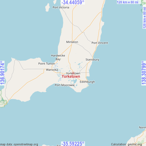
Yorketown GPS coordinates[2]
35° 1' 6.42" South, 137° 36' 17.496" East
| Map corner | latitude | longitude |
|---|---|---|
| Upper-left | -34.44059°, | 136.90174° |
| Center: | -35.01845°, | 137.60486° |
| Lower-right: | -35.59225°, | 138.30799° |
| Map W x H: | 128.1×128.1 km | = 79.6×79.6mi |
| max Lat: | -10.58257° ⇑71.8% North |
| Yorketown: | -35.01845° |
| min Lat: | ⇓28.2% South -43.31423° |
| min Long | Yorketown | max Long |
| 113.53327° | 137.60486° | 153.61246° |
| W 14.3%⇐ | ⇒85.7% E |
Elevation
Elevation of Yorketown is 25 m = 82 ft, and this is 97 m = 318 ft below average elevation for this country.
| Max E: |
1715 m = 5627 ft | 67.2% |
| Avg. | 122 m = 400 ft | |
| Yorketown | 25 m = 82 ft | |
Min E: |
-2 m = -7 ft | 32.8% |
See also: Australia elevation on elevation.city.
Geographical zone
Yorketown is located in South temperate zone (between Tropic of Capricorn and the Antarctic Circle). Distance of this Southern Tropic circle is 1287.8 km =800.2 mi to North.| Distance of | km | miles | from Yorketown |
|---|---|---|---|
| Equator | 3893.7 | 2419.4 | to North |
| Tropic Capricorn | 1287.8 | 800.2 | to North |
| Antarctic Circle | 3507.5 | 2179.5 | to South |
| South Pole | 6113.4 | 3798.7 | to South |


Nearby cities:
15 places around Yorketown: (largest is in red/bold)
• Ardrossan
72.3 km =44.9 mi,  23°
23°
• Christies Beach
80.1 km =49.8 mi,  99°
99°
• Grange
81.7 km =50.8 mi,  80°
80°
• Honiton
11.7 km =7.3 mi,  159°
159°
• Kingscote
70.9 km =44.1 mi,  177°
177°
• Maitland
71.9 km =44.7 mi,  4°
4°
• Minlaton
27.5 km =17.1 mi,  358°
358°
• Moana
81.6 km =50.7 mi, 103°
• Normanville
80.6 km =50.1 mi,  126°
126°
• O'Sullivan Beach
79.8 km =49.6 mi, 98°
• Port Noarlunga
80.1 km =49.8 mi, 100°
• Port Noarlunga South
80.5 km =50 mi, 102°
• Seaford
81.5 km =50.6 mi, 103°
• Stansbury
21.3 km =13.2 mi,  55°
55°
• Tennyson
81.6 km =50.7 mi, 79°
Sources, notices
• [Note1] Compared only with cities in Australia existing in our database
• [Src1] Map data: © OpenStreetMap contributors (CC-BY-SA)
• [Src2] Other city data from geonames.org with taken over terms of usage.
• [Src3] Geographical zone / Annual Mean Temperature by Robert A. Rohde @ Wikipedia
