Cottesloe geodata
Cottesloe (Western Australia) is a populated place; located in Australia in Australia/Perth (GMT+8) time zone. With population of 7,136 people, there are 958 cities with bigger population in this country. Compared to other cities in Australia, 65.3% of cities are located further ↓South; 97.3% of cities are located further →East and 68.6% of cities have higher elevation than Cottesloe. Note1


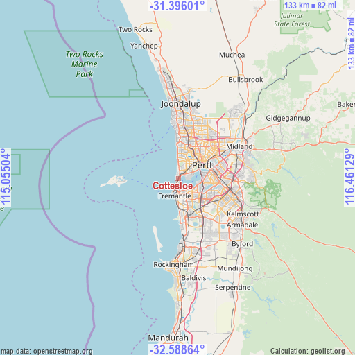
Cottesloe GPS coordinates[2]
31° 59' 39.336" South, 115° 45' 29.376" East
| Map corner | latitude | longitude |
|---|---|---|
| Upper-left | -31.39601°, | 115.05504° |
| Center: | -31.99426°, | 115.75816° |
| Lower-right: | -32.58864°, | 116.46129° |
| Map W x H: | 132.6×132.6 km | = 82.4×82.4mi |
| max Lat: | -10.58257° ⇑34.7% North |
| Cottesloe: | -31.99426° |
| min Lat: | ⇓65.3% South -43.31423° |
| min Long | Cottesloe | max Long |
| 113.53327° | 115.75816° | 153.61246° |
| W 2.7%⇐ | ⇒97.3% E |
Elevation
Elevation of Cottesloe is 24 m = 79 ft, and this is 98 m = 322 ft below average elevation for this country.
| Max E: |
1715 m = 5627 ft | 68.6% |
| Avg. | 122 m = 400 ft | |
| Cottesloe | 24 m = 79 ft | |
Min E: |
-2 m = -7 ft | 31.4% |
See also: Australia elevation on elevation.city.
Geographical zone
Cottesloe is located in South temperate zone (between Tropic of Capricorn and the Antarctic Circle). Distance of this Southern Tropic circle is 951.5 km =591.2 mi to North.| Distance of | km | miles | from Cottesloe |
|---|---|---|---|
| Equator | 3557.4 | 2210.5 | to North |
| Tropic Capricorn | 951.5 | 591.2 | to North |
| Antarctic Circle | 3843.7 | 2388.4 | to South |
| South Pole | 6449.6 | 4007.6 | to South |


Nearby cities:
15 places around Cottesloe: (largest is in red/bold)
• Attadale
5.4 km =3.4 mi,  129°
129°
• Bicton
4.4 km =2.7 mi,  147°
147°
• Claremont
2.8 km =1.7 mi,  54°
54°
• Crawley
5.6 km =3.5 mi,  78°
78°
• Dalkeith
3.9 km =2.4 mi,  91°
91°
• East Fremantle
5 km =3.1 mi,  169°
169°
• Melville
6.5 km =4 mi,  141°
141°
• Mosman Park
1.3 km =0.8 mi,  156°
156°
• Mount Claremont
4.3 km =2.7 mi,  33°
33°
• Nedlands
4.8 km =3 mi,  73°
73°
• North Fremantle
4.4 km =2.7 mi,  190°
190°
• Palmyra
6.2 km =3.9 mi, 155°
• Peppermint Grove
1.1 km =0.7 mi,  117°
117°
• Shenton Park
5.7 km =3.5 mi,  41°
41°
• Swanbourne
3 km =1.9 mi,  16°
16°
Sources, notices
• [Note1] Compared only with cities in Australia existing in our database
• [Src1] Map data: © OpenStreetMap contributors (CC-BY-SA)
• [Src2] Other city data from geonames.org with taken over terms of usage.
• [Src3] Geographical zone / Annual Mean Temperature by Robert A. Rohde @ Wikipedia
