Bullsbrook geodata
Bullsbrook (Western Australia) is a section of populated place; located in Australia in Australia/Perth (GMT+8) time zone. With population of 5,102 people, there are 1449 cities with bigger population in this country. Compared to other cities in Australia, 69% of cities are located further ↓South; 92.5% of cities are located further →East and 61.8% of cities have higher elevation than Bullsbrook. Note1


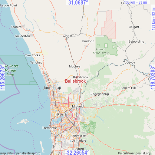
Bullsbrook GPS coordinates[2]
31° 40' 8.58" South, 115° 59' 59.64" East
| Map corner | latitude | longitude |
|---|---|---|
| Upper-left | -31.0687°, | 115.29678° |
| Center: | -31.66905°, | 115.9999° |
| Lower-right: | -32.26554°, | 116.70303° |
| Map W x H: | 133.1×133.1 km | = 82.7×82.7mi |
| max Lat: | -10.58257° ⇑31% North |
| Bullsbrook: | -31.66905° |
| min Lat: | ⇓69% South -43.31423° |
| min Long | Bullsbrook | max Long |
| 113.53327° | 115.9999° | 153.61246° |
| W 7.5%⇐ | ⇒92.5% E |
Elevation
Elevation of Bullsbrook is 30 m = 98 ft, and this is 92 m = 302 ft below average elevation for this country.
| Max E: |
1715 m = 5627 ft | 61.8% |
| Avg. | 122 m = 400 ft | |
| Bullsbrook | 30 m = 98 ft | |
Min E: |
-2 m = -7 ft | 38.2% |
See also: Australia elevation on elevation.city.
Geographical zone
Bullsbrook is located in South temperate zone (between Tropic of Capricorn and the Antarctic Circle). Distance of this Southern Tropic circle is 915.3 km =568.7 mi to North.| Distance of | km | miles | from Bullsbrook |
|---|---|---|---|
| Equator | 3521.3 | 2188 | to North |
| Tropic Capricorn | 915.3 | 568.7 | to North |
| Antarctic Circle | 3879.9 | 2410.9 | to South |
| South Pole | 6485.8 | 4030.1 | to South |


Nearby cities:
15 places around Bullsbrook: (largest is in red/bold)
• Aveley
12.5 km =7.8 mi,  184°
184°
• Banksia Grove
18.7 km =11.6 mi,  260°
260°
• Brabham
17.8 km =11.1 mi,  187°
187°
• Brigadoon
13.4 km =8.3 mi,  149°
149°
• Ellenbrook
11.3 km =7 mi, 194°
• Gnangara
17.4 km =10.8 mi,  226°
226°
• Henley Brook
16.1 km =10 mi, 183°
• Herne Hill
17.5 km =10.9 mi,  172°
172°
• Lower Chittering
14.6 km =9.1 mi,  49°
49°
• Mariginiup
15.5 km =9.6 mi,  252°
252°
• Millendon
15.8 km =9.8 mi, 167°
• Muchea
10 km =6.2 mi,  344°
344°
• Pearce
1.6 km =1 mi,  80°
80°
• The Vines
9.6 km =6 mi, 178°
• Upper Swan
11.5 km =7.1 mi, 166°
Sources, notices
• [Note1] Compared only with cities in Australia existing in our database
• [Src1] Map data: © OpenStreetMap contributors (CC-BY-SA)
• [Src2] Other city data from geonames.org with taken over terms of usage.
• [Src3] Geographical zone / Annual Mean Temperature by Robert A. Rohde @ Wikipedia
