Lower Chittering geodata
Lower Chittering (Western Australia) is a populated place; located in Australia in Australia/Perth (GMT+8) time zone. With population of 2,048 people, there are 2869 cities with bigger population in this country. Compared to other cities in Australia, 69.4% of cities are located further ↓South; 91.4% of cities are located further →East and 84% of cities have lower elevation than Lower Chittering. Note1


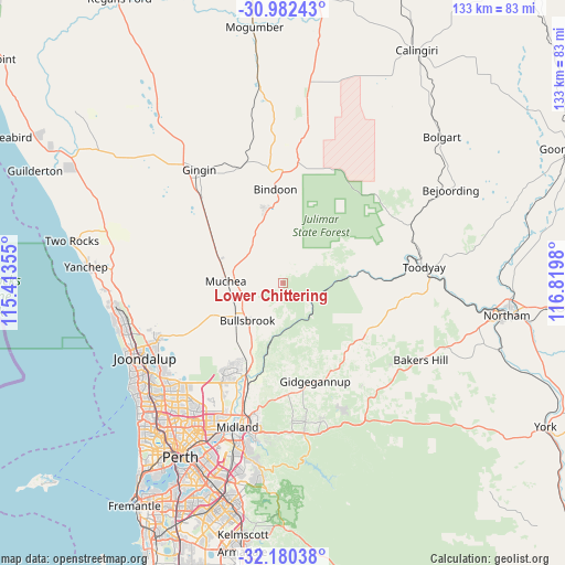
Lower Chittering GPS coordinates[2]
31° 34' 59.988" South, 116° 7' 0.012" East
| Map corner | latitude | longitude |
|---|---|---|
| Upper-left | -30.98243°, | 115.41355° |
| Center: | -31.58333°, | 116.11667° |
| Lower-right: | -32.18038°, | 116.8198° |
| Map W x H: | 133.2×133.2 km | = 82.8×82.8mi |
| max Lat: | -10.58257° ⇑30.6% North |
| Lower Chittering: | -31.58333° |
| min Lat: | ⇓69.4% South -43.31423° |
| min Long | Lower Chitterin | max Long |
| 113.53327° | 116.11667° | 153.61246° |
| W 8.6%⇐ | ⇒91.4% E |
Elevation
Elevation of Lower Chittering is 231 m = 758 ft, and this is 109 m = 358 ft above average elevation for this country.
| Max E: |
1715 m = 5627 ft | 16% |
| Lower Chittering | 231 m 758 ft | |
| Avg. | 122 m = 400 ft | |
Min E: |
-2 m = -7 ft | 84% |
See also: Australia elevation on elevation.city.
Geographical zone
Lower Chittering is located in South temperate zone (between Tropic of Capricorn and the Antarctic Circle). Distance of this Southern Tropic circle is 905.8 km =562.8 mi to North.| Distance of | km | miles | from Lower Chittering |
|---|---|---|---|
| Equator | 3511.7 | 2182.1 | to North |
| Tropic Capricorn | 905.8 | 562.8 | to North |
| Antarctic Circle | 3889.4 | 2416.8 | to South |
| South Pole | 6495.3 | 4036 | to South |


Nearby cities:
15 places around Lower Chittering: (largest is in red/bold)
• Aveley
25.1 km =15.6 mi,  208°
208°
• Bindoon
22 km =13.7 mi,  355°
355°
• Brigadoon
21.5 km =13.4 mi,  191°
191°
• Bullsbrook
14.6 km =9.1 mi,  229°
229°
• Chittering
13.3 km =8.3 mi,  344°
344°
• Ellenbrook
24.8 km =15.4 mi, 214°
• Gidgegannup
20.2 km =12.6 mi,  160°
160°
• Henley Brook
28.4 km =17.6 mi, 205°
• Herne Hill
28.4 km =17.6 mi,  198°
198°
• Millendon
26.1 km =16.2 mi, 196°
• Morangup
19 km =11.8 mi,  119°
119°
• Muchea
13.7 km =8.5 mi,  270°
270°
• Pearce
13.2 km =8.2 mi, 225°
• The Vines
21.9 km =13.6 mi, 209°
• Upper Swan
22.4 km =13.9 mi, 202°
Sources, notices
• [Note1] Compared only with cities in Australia existing in our database
• [Src1] Map data: © OpenStreetMap contributors (CC-BY-SA)
• [Src2] Other city data from geonames.org with taken over terms of usage.
• [Src3] Geographical zone / Annual Mean Temperature by Robert A. Rohde @ Wikipedia
