Muchea geodata
Muchea (Western Australia) is a populated place; located in Australia in Australia/Perth (GMT+8) time zone. With population of 930 people, there are 3931 cities with bigger population in this country. Compared to other cities in Australia, 69.5% of cities are located further ↓South; 92.8% of cities are located further →East and 54.5% of cities have lower elevation than Muchea. Note1


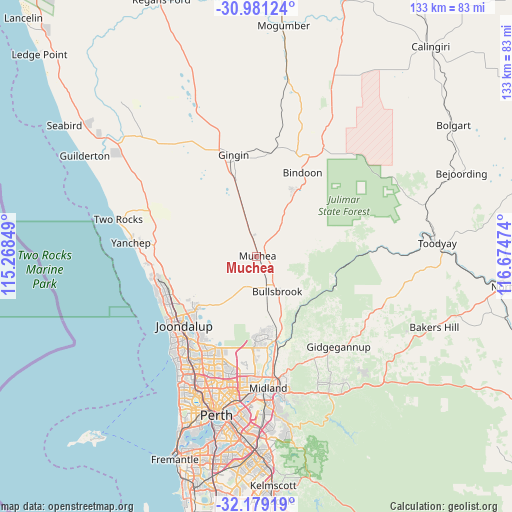
Muchea GPS coordinates[2]
31° 34' 55.704" South, 115° 58' 17.796" East
| Map corner | latitude | longitude |
|---|---|---|
| Upper-left | -30.98124°, | 115.26849° |
| Center: | -31.58214°, | 115.97161° |
| Lower-right: | -32.17919°, | 116.67474° |
| Map W x H: | 133.2×133.2 km | = 82.8×82.8mi |
| max Lat: | -10.58257° ⇑30.5% North |
| Muchea: | -31.58214° |
| min Lat: | ⇓69.5% South -43.31423° |
| min Long | Muchea | max Long |
| 113.53327° | 115.97161° | 153.61246° |
| W 7.2%⇐ | ⇒92.8% E |
Elevation
Elevation of Muchea is 52 m = 171 ft, and this is 70 m = 230 ft below average elevation for this country.
| Max E: |
1715 m = 5627 ft | 45.5% |
| Avg. | 122 m = 400 ft | |
| Muchea | 52 m = 171 ft | |
Min E: |
-2 m = -7 ft | 54.5% |
See also: Australia elevation on elevation.city.
Geographical zone
Muchea is located in South temperate zone (between Tropic of Capricorn and the Antarctic Circle). Distance of this Southern Tropic circle is 905.7 km =562.8 mi to North.| Distance of | km | miles | from Muchea |
|---|---|---|---|
| Equator | 3511.6 | 2182 | to North |
| Tropic Capricorn | 905.7 | 562.8 | to North |
| Antarctic Circle | 3889.6 | 2416.9 | to South |
| South Pole | 6495.5 | 4036.1 | to South |


Nearby cities:
15 places around Muchea: (largest is in red/bold)
• Ashby
23.5 km =14.6 mi,  224°
224°
• Aveley
22.2 km =13.8 mi,  175°
175°
• Banksia Grove
20.2 km =12.6 mi,  231°
231°
• Brigadoon
23.2 km =14.4 mi,  155°
155°
• Bullsbrook
10 km =6.2 mi, 164°
• Carramar
22.4 km =13.9 mi,  237°
237°
• Chittering
16.4 km =10.2 mi,  38°
38°
• Ellenbrook
20.6 km =12.8 mi, 180°
• Lower Chittering
13.7 km =8.5 mi,  90°
90°
• Mariginiup
18.8 km =11.7 mi, 220°
• Pearce
10.3 km =6.4 mi, 155°
• Sinagra
23.7 km =14.7 mi, 221°
• Tapping
22.6 km =14 mi, 227°
• The Vines
19.4 km =12.1 mi,  171°
171°
• Upper Swan
21.5 km =13.4 mi, 165°
Sources, notices
• [Note1] Compared only with cities in Australia existing in our database
• [Src1] Map data: © OpenStreetMap contributors (CC-BY-SA)
• [Src2] Other city data from geonames.org with taken over terms of usage.
• [Src3] Geographical zone / Annual Mean Temperature by Robert A. Rohde @ Wikipedia
