Balingup geodata
Balingup (Western Australia) is a populated place; located in Australia in Australia/Perth (GMT+8) time zone. With population of 529 people, there are 4785 cities with bigger population in this country. Compared to other cities in Australia, 52% of cities are located further ↑North; 93% of cities are located further →East and 86.5% of cities have lower elevation than Balingup. Note1


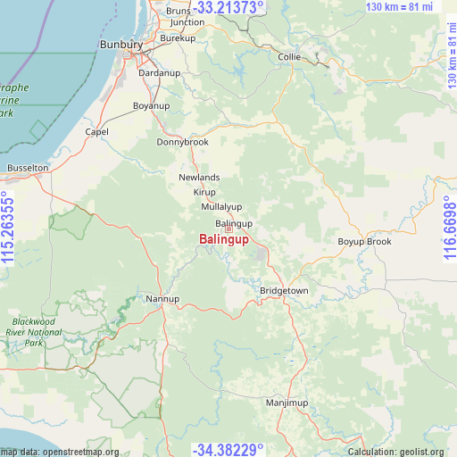
Balingup GPS coordinates[2]
33° 48' 0" South, 115° 58' 0.012" East
| Map corner | latitude | longitude |
|---|---|---|
| Upper-left | -33.21373°, | 115.26355° |
| Center: | -33.8°, | 115.96667° |
| Lower-right: | -34.38229°, | 116.6698° |
| Map W x H: | 129.9×129.9 km | = 80.7×80.7mi |
| max Lat: | -10.58257° ⇑52% North |
| Balingup: | -33.8° |
| min Lat: | ⇓48% South -43.31423° |
| min Long | Balingup | max Long |
| 113.53327° | 115.96667° | 153.61246° |
| W 7%⇐ | ⇒93% E |
Elevation
Elevation of Balingup is 277 m = 909 ft, and this is 155 m = 509 ft above average elevation for this country.
| Max E: |
1715 m = 5627 ft | 13.5% |
| Balingup | 277 m 909 ft | |
| Avg. | 122 m = 400 ft | |
Min E: |
-2 m = -7 ft | 86.5% |
See also: Australia elevation on elevation.city.
Geographical zone
Balingup is located in South temperate zone (between Tropic of Capricorn and the Antarctic Circle). Distance of this Southern Tropic circle is 1152.3 km =716 mi to North.| Distance of | km | miles | from Balingup |
|---|---|---|---|
| Equator | 3758.2 | 2335.2 | to North |
| Tropic Capricorn | 1152.3 | 716 | to North |
| Antarctic Circle | 3643 | 2263.7 | to South |
| South Pole | 6248.9 | 3882.9 | to South |


Nearby cities:
15 places around Balingup: (largest is in red/bold)
• Allanson
53.1 km =33 mi,  13°
13°
• Argyle
33.6 km =20.9 mi,  327°
327°
• Boyanup
41.6 km =25.8 mi, 327°
• Boyup Brook
39.1 km =24.3 mi,  95°
95°
• Bridgetown
23.9 km =14.9 mi,  139°
139°
• Capel
46 km =28.6 mi,  305°
305°
• Collie
51.8 km =32.2 mi,  19°
19°
• Dalyellup
54.4 km =33.8 mi,  323°
323°
• Dardanup West
51 km =31.7 mi, 334°
• Donnybrook
28.6 km =17.8 mi, 332°
• Gelorup
51.5 km =32 mi, 324°
• Manjimup
51.8 km =32.2 mi,  161°
161°
• Nannup
27.3 km =17 mi,  223°
223°
• Stratham
51.4 km =31.9 mi, 316°
• Yalyalup
52.9 km =32.9 mi,  285°
285°
Sources, notices
• [Note1] Compared only with cities in Australia existing in our database
• [Src1] Map data: © OpenStreetMap contributors (CC-BY-SA)
• [Src2] Other city data from geonames.org with taken over terms of usage.
• [Src3] Geographical zone / Annual Mean Temperature by Robert A. Rohde @ Wikipedia
