Bridgetown geodata
Bridgetown (Western Australia) is a populated place; located in Australia in Australia/Perth (GMT+8) time zone. With population of 2,751 people, there are 2409 cities with bigger population in this country. Compared to other cities in Australia, 58.1% of cities are located further ↑North; 91.4% of cities are located further →East and 77.4% of cities have lower elevation than Bridgetown. Note1


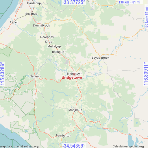
Bridgetown GPS coordinates[2]
33° 57' 44.712" South, 116° 8' 9.528" East
| Map corner | latitude | longitude |
|---|---|---|
| Upper-left | -33.37725°, | 115.43286° |
| Center: | -33.96242°, | 116.13598° |
| Lower-right: | -34.54359°, | 116.83911° |
| Map W x H: | 129.7×129.7 km | = 80.6×80.6mi |
| max Lat: | -10.58257° ⇑58.1% North |
| Bridgetown: | -33.96242° |
| min Lat: | ⇓41.9% South -43.31423° |
| min Long | Bridgetown | max Long |
| 113.53327° | 116.13598° | 153.61246° |
| W 8.6%⇐ | ⇒91.4% E |
Elevation
Elevation of Bridgetown is 150 m = 492 ft, and this is 28 m = 92 ft above average elevation for this country.
| Max E: |
1715 m = 5627 ft | 22.6% |
| Bridgetown | 150 m 492 ft | |
| Avg. | 122 m = 400 ft | |
Min E: |
-2 m = -7 ft | 77.4% |
See also: Australia elevation on elevation.city.
Geographical zone
Bridgetown is located in South temperate zone (between Tropic of Capricorn and the Antarctic Circle). Distance of this Southern Tropic circle is 1170.3 km =727.2 mi to North.| Distance of | km | miles | from Bridgetown |
|---|---|---|---|
| Equator | 3776.3 | 2346.5 | to North |
| Tropic Capricorn | 1170.3 | 727.2 | to North |
| Antarctic Circle | 3624.9 | 2252.4 | to South |
| South Pole | 6230.8 | 3871.6 | to South |


Nearby cities:
15 places around Bridgetown: (largest is in red/bold)
• Allanson
69.7 km =43.3 mi,  357°
357°
• Argyle
57.3 km =35.6 mi,  323°
323°
• Balingup
23.9 km =14.9 mi, 319°
• Boyanup
65.3 km =40.6 mi, 324°
• Boyup Brook
27.3 km =17 mi,  58°
58°
• Capel
69.5 km =43.2 mi,  310°
310°
• Collie
66.8 km =41.5 mi,  1°
1°
• Dardanup West
74.3 km =46.2 mi,  329°
329°
• Donnybrook
52.2 km =32.4 mi, 326°
• Gelorup
75.4 km =46.9 mi, 322°
• Manjimup
31 km =19.3 mi,  178°
178°
• Nannup
34.3 km =21.3 mi,  266°
266°
• Pemberton
54.2 km =33.7 mi,  189°
189°
• Stratham
75.3 km =46.8 mi, 317°
• Yalyalup
73.9 km =45.9 mi,  295°
295°
Sources, notices
• [Note1] Compared only with cities in Australia existing in our database
• [Src1] Map data: © OpenStreetMap contributors (CC-BY-SA)
• [Src2] Other city data from geonames.org with taken over terms of usage.
• [Src3] Geographical zone / Annual Mean Temperature by Robert A. Rohde @ Wikipedia
