Boyup Brook geodata
Boyup Brook (Western Australia) is a populated place; located in Australia in Australia/Perth (GMT+8) time zone. With population of 873 people, there are 4013 cities with bigger population in this country. Compared to other cities in Australia, 53.1% of cities are located further ↑North; 91% of cities are located further →East and 82.9% of cities have lower elevation than Boyup Brook. Note1


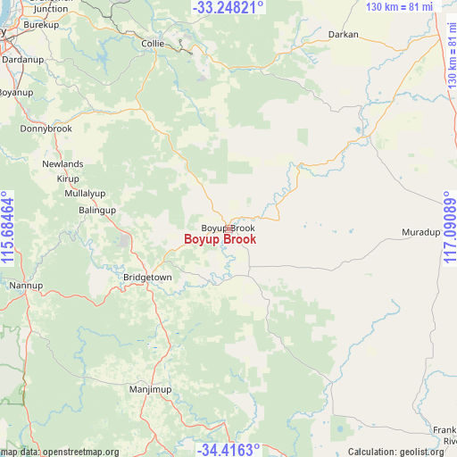
Boyup Brook GPS coordinates[2]
33° 50' 3.3" South, 116° 23' 15.936" East
| Map corner | latitude | longitude |
|---|---|---|
| Upper-left | -33.24821°, | 115.68464° |
| Center: | -33.83425°, | 116.38776° |
| Lower-right: | -34.4163°, | 117.09089° |
| Map W x H: | 129.9×129.9 km | = 80.7×80.7mi |
| max Lat: | -10.58257° ⇑53.1% North |
| Boyup Brook: | -33.83425° |
| min Lat: | ⇓46.9% South -43.31423° |
| min Long | Boyup Brook | max Long |
| 113.53327° | 116.38776° | 153.61246° |
| W 9%⇐ | ⇒91% E |
Elevation
Elevation of Boyup Brook is 217 m = 712 ft, and this is 95 m = 312 ft above average elevation for this country.
| Max E: |
1715 m = 5627 ft | 17.1% |
| Boyup Brook | 217 m 712 ft | |
| Avg. | 122 m = 400 ft | |
Min E: |
-2 m = -7 ft | 82.9% |
See also: Australia elevation on elevation.city.
Geographical zone
Boyup Brook is located in South temperate zone (between Tropic of Capricorn and the Antarctic Circle). Distance of this Southern Tropic circle is 1156.1 km =718.4 mi to North.| Distance of | km | miles | from Boyup Brook |
|---|---|---|---|
| Equator | 3762 | 2337.6 | to North |
| Tropic Capricorn | 1156.1 | 718.4 | to North |
| Antarctic Circle | 3639.2 | 2261.3 | to South |
| South Pole | 6245 | 3880.5 | to South |


Nearby cities:
15 places around Boyup Brook: (largest is in red/bold)
• Allanson
61.5 km =38.2 mi,  334°
334°
• Argyle
65.5 km =40.7 mi,  299°
299°
• Balingup
39.1 km =24.3 mi,  275°
275°
• Boyanup
72.5 km =45 mi, 302°
• Bridgetown
27.3 km =17 mi,  238°
238°
• Burekup
79.1 km =49.2 mi,  317°
317°
• Capel
82.3 km =51.1 mi,  291°
291°
• Collie
56.7 km =35.2 mi,  337°
337°
• Dardanup West
78.7 km =48.9 mi,  309°
309°
• Donnybrook
59.7 km =37.1 mi, 299°
• Kojonup
71.3 km =44.3 mi,  89°
89°
• Manjimup
50.5 km =31.4 mi,  206°
206°
• Nannup
59.7 km =37.1 mi,  254°
254°
• Pemberton
75 km =46.6 mi, 205°
• Roelands
80.9 km =50.3 mi, 319°
Sources, notices
• [Note1] Compared only with cities in Australia existing in our database
• [Src1] Map data: © OpenStreetMap contributors (CC-BY-SA)
• [Src2] Other city data from geonames.org with taken over terms of usage.
• [Src3] Geographical zone / Annual Mean Temperature by Robert A. Rohde @ Wikipedia
