Allanson geodata
Allanson (Western Australia) is a populated place; located in Australia in Australia/Perth (GMT+8) time zone. With population of 588 people, there are 4603 cities with bigger population in this country. Compared to other cities in Australia, 55.2% of cities are located further ↓South; 91.5% of cities are located further →East and 80.8% of cities have lower elevation than Allanson. Note1


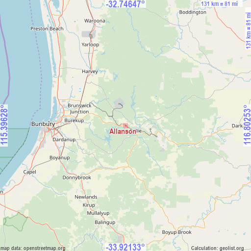
Allanson GPS coordinates[2]
33° 20' 9.168" South, 116° 5' 57.84" East
| Map corner | latitude | longitude |
|---|---|---|
| Upper-left | -32.74647°, | 115.39628° |
| Center: | -33.33588°, | 116.0994° |
| Lower-right: | -33.92133°, | 116.80253° |
| Map W x H: | 130.6×130.6 km | = 81.2×81.2mi |
| max Lat: | -10.58257° ⇑44.8% North |
| Allanson: | -33.33588° |
| min Lat: | ⇓55.2% South -43.31423° |
| min Long | Allanson | max Long |
| 113.53327° | 116.0994° | 153.61246° |
| W 8.5%⇐ | ⇒91.5% E |
Elevation
Elevation of Allanson is 190 m = 623 ft, and this is 68 m = 223 ft above average elevation for this country.
| Max E: |
1715 m = 5627 ft | 19.2% |
| Allanson | 190 m 623 ft | |
| Avg. | 122 m = 400 ft | |
Min E: |
-2 m = -7 ft | 80.8% |
See also: Australia elevation on elevation.city.
Geographical zone
Allanson is located in South temperate zone (between Tropic of Capricorn and the Antarctic Circle). Distance of this Southern Tropic circle is 1100.7 km =683.9 mi to North.| Distance of | km | miles | from Allanson |
|---|---|---|---|
| Equator | 3706.6 | 2303.2 | to North |
| Tropic Capricorn | 1100.7 | 683.9 | to North |
| Antarctic Circle | 3694.6 | 2295.7 | to South |
| South Pole | 6300.5 | 3914.9 | to South |


Nearby cities:
15 places around Allanson: (largest is in red/bold)
• Argyle
38.4 km =23.9 mi,  232°
232°
• Australind
36.3 km =22.6 mi,  280°
280°
• Boyanup
38.1 km =23.7 mi,  244°
244°
• Brunswick
24.8 km =15.4 mi,  297°
297°
• Burekup
26.7 km =16.6 mi, 276°
• Collie
6 km =3.7 mi,  118°
118°
• Dardanup West
34.8 km =21.6 mi,  260°
260°
• Donnybrook
36.5 km =22.7 mi,  224°
224°
• Eaton
36.7 km =22.8 mi,  273°
273°
• Glen Iris
39.5 km =24.5 mi, 269°
• Harvey
33.3 km =20.7 mi,  329°
329°
• Leschenault
36.2 km =22.5 mi,  286°
286°
• Millbridge
34 km =21.1 mi, 275°
• Pelican Point
37.8 km =23.5 mi, 272°
• Roelands
26.9 km =16.7 mi, 282°
Sources, notices
• [Note1] Compared only with cities in Australia existing in our database
• [Src1] Map data: © OpenStreetMap contributors (CC-BY-SA)
• [Src2] Other city data from geonames.org with taken over terms of usage.
• [Src3] Geographical zone / Annual Mean Temperature by Robert A. Rohde @ Wikipedia
