Lancelin geodata
Lancelin (Western Australia) is a populated place; located in Australia in Australia/Perth (GMT+8) time zone. With population of 693 people, there are 4336 cities with bigger population in this country. Compared to other cities in Australia, 70.7% of cities are located further ↓South; 98.9% of cities are located further →East and 95.5% of cities have higher elevation than Lancelin. Note1


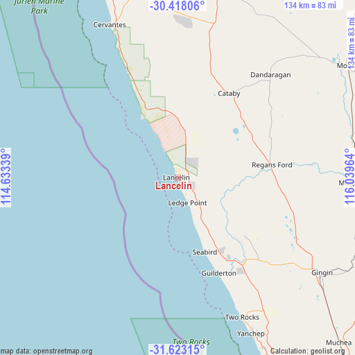
Lancelin GPS coordinates[2]
31° 1' 21.036" South, 115° 20' 11.436" East
| Map corner | latitude | longitude |
|---|---|---|
| Upper-left | -30.41806°, | 114.63339° |
| Center: | -31.02251°, | 115.33651° |
| Lower-right: | -31.62315°, | 116.03964° |
| Map W x H: | 134×134 km | = 83.3×83.3mi |
| max Lat: | -10.58257° ⇑29.3% North |
| Lancelin: | -31.02251° |
| min Lat: | ⇓70.7% South -43.31423° |
| min Long | Lancelin | max Long |
| 113.53327° | 115.33651° | 153.61246° |
| W 1.1%⇐ | ⇒98.9% E |
Elevation
Elevation of Lancelin is 6 m = 20 ft, and this is 116 m = 381 ft below average elevation for this country.
| Max E: |
1715 m = 5627 ft | 95.5% |
| Avg. | 122 m = 400 ft | |
| Lancelin | 6 m = 20 ft | |
Min E: |
-2 m = -7 ft | 4.5% |
See also: Australia elevation on elevation.city.
Geographical zone
Lancelin is located in South temperate zone (between Tropic of Capricorn and the Antarctic Circle). Distance of this Southern Tropic circle is 843.5 km =524.1 mi to North.| Distance of | km | miles | from Lancelin |
|---|---|---|---|
| Equator | 3449.4 | 2143.4 | to North |
| Tropic Capricorn | 843.5 | 524.1 | to North |
| Antarctic Circle | 3951.8 | 2455.5 | to South |
| South Pole | 6557.7 | 4074.8 | to South |


Nearby cities:
15 places around Lancelin: (largest is in red/bold)
• Alkimos
75.3 km =46.8 mi,  153°
153°
• Butler
77.3 km =48 mi, 153°
• Cervantes
63.9 km =39.7 mi,  336°
336°
• Eglinton
71.1 km =44.2 mi, 151°
• Gabbadah
34 km =21.1 mi, 151°
• Gingin
65 km =40.4 mi,  123°
123°
• Jindalee
77.6 km =48.2 mi, 153°
• Merriwa
79.9 km =49.6 mi, 153°
• Mindarie
82.1 km =51 mi, 154°
• Moora
76.6 km =47.6 mi,  56°
56°
• Quinns Rocks
80.4 km =50 mi, 154°
• Ridgewood
80 km =49.7 mi, 152°
• Two Rocks
58.2 km =36.2 mi,  155°
155°
• Woodridge
42.5 km =26.4 mi,  144°
144°
• Yanchep
64.7 km =40.2 mi, 154°
Sources, notices
• [Note1] Compared only with cities in Australia existing in our database
• [Src1] Map data: © OpenStreetMap contributors (CC-BY-SA)
• [Src2] Other city data from geonames.org with taken over terms of usage.
• [Src3] Geographical zone / Annual Mean Temperature by Robert A. Rohde @ Wikipedia
