Moora geodata
Moora (Western Australia) is a populated place; located in Australia in Australia/Perth (GMT+8) time zone. With population of 1,819 people, there are 3031 cities with bigger population in this country. Compared to other cities in Australia, 71.4% of cities are located further ↓South; 92.3% of cities are located further →East and 82.3% of cities have lower elevation than Moora. Note1


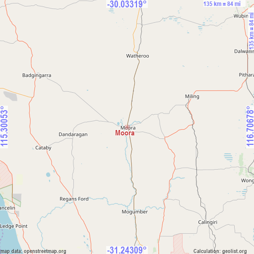
Moora GPS coordinates[2]
30° 38' 24.108" South, 116° 0' 13.14" East
| Map corner | latitude | longitude |
|---|---|---|
| Upper-left | -30.03319°, | 115.30053° |
| Center: | -30.64003°, | 116.00365° |
| Lower-right: | -31.24309°, | 116.70678° |
| Map W x H: | 134.5×134.5 km | = 83.6×83.6mi |
| max Lat: | -10.58257° ⇑28.6% North |
| Moora: | -30.64003° |
| min Lat: | ⇓71.4% South -43.31423° |
| min Long | Moora | max Long |
| 113.53327° | 116.00365° | 153.61246° |
| W 7.7%⇐ | ⇒92.3% E |
Elevation
Elevation of Moora is 209 m = 686 ft, and this is 87 m = 285 ft above average elevation for this country.
| Max E: |
1715 m = 5627 ft | 17.7% |
| Moora | 209 m 686 ft | |
| Avg. | 122 m = 400 ft | |
Min E: |
-2 m = -7 ft | 82.3% |
See also: Australia elevation on elevation.city.
Geographical zone
Moora is located in South temperate zone (between Tropic of Capricorn and the Antarctic Circle). Distance of this Southern Tropic circle is 800.9 km =497.7 mi to North.| Distance of | km | miles | from Moora |
|---|---|---|---|
| Equator | 3406.9 | 2116.9 | to North |
| Tropic Capricorn | 800.9 | 497.7 | to North |
| Antarctic Circle | 3994.3 | 2481.9 | to South |
| South Pole | 6600.2 | 4101.2 | to South |


Nearby cities:
15 places around Moora: (largest is in red/bold)
• Bindoon
83.5 km =51.9 mi,  173°
173°
• Cervantes
91.1 km =56.6 mi,  280°
280°
• Chittering
92.3 km =57.4 mi,  175°
175°
• Coondle
101.9 km =63.3 mi,  156°
156°
• Dalwallinu
74.5 km =46.3 mi,  57°
57°
• Gabbadah
86.6 km =53.8 mi,  213°
213°
• Gingin
79.2 km =49.2 mi,  186°
186°
• Jurien Bay
99.7 km =62 mi,  291°
291°
• Lancelin
76.6 km =47.6 mi,  236°
236°
• Lower Chittering
105.4 km =65.5 mi, 174°
• Muchea
104.8 km =65.1 mi, 181°
• Two Rocks
103.5 km =64.3 mi,  202°
202°
• West Toodyay
106.8 km =66.4 mi, 158°
• Wongan Hills
73.9 km =45.9 mi,  112°
112°
• Woodridge
86.4 km =53.7 mi, 206°
Sources, notices
• [Note1] Compared only with cities in Australia existing in our database
• [Src1] Map data: © OpenStreetMap contributors (CC-BY-SA)
• [Src2] Other city data from geonames.org with taken over terms of usage.
• [Src3] Geographical zone / Annual Mean Temperature by Robert A. Rohde @ Wikipedia
